
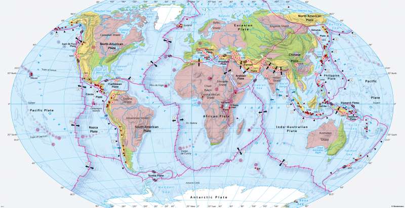
The World - Plate tectonics, volcanism and earthquakes
Plate tectonics
978-3-14-100890-6 | Page 14 | Ill. 1
Overview
The upper rock layer of the Earth is formed either by continental crust (continents and the adjacent shelf areas) or by oceanic crust (oceans outside the shelf areas; see comment on physical map inside the front cover). Continental crust has a smaller density and greater thickness than oceanic crust.
Classification of land masses
All large contiguous landmasses, the continents, have cores made of metamorphic and plutonic rocks (shields, primeval continents), most of which date from the Earth's primeval period, the Precambrian. While such cores build up almost the entire continent of Africa, they are spread out over much smaller areas in Eurasia, for example.
The continental cores were repeatedly spatially expanded at their edges in the course of mountain building. In the map, the resulting mountains are shown in shades of green or yellow depending on their age. After a stage of geosynclinal subsidence over continental subsoil or in a marginal position between continent and ocean, they underwent the actual stage of mountain building with metamorphosis, plutonism, folding/sheet building and uplift/heave. Subsidence zones accompanied the outer margins of the formed mountains and absorbed their erosional debris.
Over geological time periods, both the old continental cores and the newly formed mountains were heavily modified. The primeval continents have now been largely eroded and levelled. Since the Cambrian, they have been flooded in some areas by shallow continental shelfs. Extensive, undisturbed areas of sedimentary rocks developed in them. In the mountains of the early fold zones, uplift has come to a standstill. Here, erosion processes dominate the development of the surface. In the mountains of the new fold zones, ongoing uplift, active volcanism, and earthquakes are widespread signs that mountain building is not yet complete. Compared to the mountains of the early fold zones, they are significantly higher and often exhibit the typical forms of high mountains (large differences in altitude in a small area, narrow valleys and gorges, scree slopes, rugged ridges and steep summit pyramids made of rock, glaciation, or traces of glacial surface formation).
Another feature of the continents are the trenches that have been sinking since the Tertiary and are often connected with the central trenches of the oceanic ridges. They are typically pronounced in the area of the Victoria Plate in East Africa. In these zones, continental crustal parts actively diverge, associated with the upwelling of lava.
Tectonic plates and their boundaries
The division of the Earth's surface into continents and oceans, as shown in the physical map inside the front cover, follows the spatial distribution of large contiguous land masses and oceans. If we look at the Earth's surface from a geological perspective, a different structure emerges. According to this, the Earth's lithosphere is divided into rigid, coherent tectonic plates consisting of continental and oceanic crust and bounded by oceanic ridges, deep-sea trenches, movements, or collision zones. However, there are also exceptions such as the Victoria Plate in Africa or the Nazca Plate, which are made up of only one type of crust. Tectonic plates move as a whole and independently of neighbouring plates on a soft zone of the Earth's mantle (see 14.2-3).
The tectonic plates vary in size: large plates such as the Eurasian, North American or Pacific plates are opposed by medium to small plates (for example, the Adriatic, Anatolian, Arabian and Iranian plates). As the map shows, there is often disagreement regarding the belonging of a region to a plate or continent. Although India, for example, is part of the continent of Asia, the Indian Plate is not part of the Eurasian Plate, but of the Indo-Australian Plate.
The type of boundary between two adjacent tectonic plates and their movements in relation to each other (diverging or converging) determine the geological processes taking place at the plate boundaries:
- If the plate boundary is marked by a mid-oceanic ridge, for example in the North Atlantic between the North American and Eurasian plates, then the two plates drift apart there. Active marine volcanism is typical, new ocean floor is formed (two to three centimetres per year in the North Atlantic, up to 15 centimetres per year in the South Pacific).
- If a plate dives under another plate in the area of a deep-sea trench, such as the Nazca plate diving under the South American plate off the Pacific coast of South America, the diving plate is melted in deeper layers of the Earth. Mountain building occurs in the area of the continental crust. Active volcanism and severe earthquakes mark the course of the plate boundary like pearls on a string, and natural disasters are frequent.
- If two plates move horizontally past each other, for example the Pacific and North American plates in California, tensions build up again and again, which are suddenly released in severe earthquakes, often associated with natural disasters.
- If two plates collide, for example the Indian-Australian and Chinese plates in India, the result is mountain building and severe earthquakes. Natural disasters often occur.
Classification of oceanic crust
The transition from continental crust to oceanic crust is marked by steep continental slopes (see 14.3). The seabed built up by oceanic crust includes shallowly sloping deep-sea basins, oceanic ridges, and deep-sea trenches.
The oceanic ridges, which extend over more than 70,000 kilometres, rise up to 3500 metres above the surrounding seabed. They run through the oceans as chains, interrupted only by cross interferences with lateral offsets. Some of them continue in the area of the continents (for example in California and New Zealand). The narrow crest regions of the ridges are marked by a central rift (see physical map inside the front cover). Fracturing, intense volcanism and formation of new ocean crust are the characteristic features of these regions (see 14.3). The elongated deep-sea trenches are separated from the surrounding seafloor by very steep slopes. The greatest known sea depths are reached in them (see physical map inside the front cover and 14.3).
Earthquakes, severe tidal waves, volcanism
Three areas of the Earth's surface are characterised by increased seismic, volcanic, and tectonic activity:
- the plate margins in oceanic areas, where earthquake centres and volcanoes are concentrated in narrow strips,
- the zones of geologically young mountain building (more scattered on the mainland than in oceanic areas),
- the fracture zones on the continents where new plate boundaries are formed.
Most earthquakes have tectonic causes and are associated with fractures and mountain building. In addition, there are earthquakes following the collapse of underground cavities and earthquakes in connection with volcanic eruptions. If two plates move in different directions at their interface, they exert pressure on each other and interlock. A uniform horizontal or vertical movement cannot develop this way in the area of the rigid earth's crust. Some of the movements are held back, which creates tensions. They are suddenly released in earthquakes when the resistance of the rocks to fracture is exceeded.
Strong earthquakes trigger subsequent processes. Above a certain magnitude, tidal waves occur after seaquakes (tsunamis). On the mainland, fissures can form, mud flows and landslides can be triggered, and subsidence can occur. Because of their widespread occurrence, their unpredictability, and the wide range of possible damage in populated areas, earthquakes are among the most dangerous natural disasters.
More than 75 percent of current volcanic activity is concentrated in the Pacific Ring of Fire. There, entire chains of active volcanoes are arranged parallel to the deep-sea trenches. This volcanism results from melting processes associated with the subsidence of the oceanic crust in the area of the subduction zones (see 14.3). In terms of appearance, the typical cone-shaped stratiform volcanoes are found above all. Volcanism along deep continental rifts is mostly basaltic in nature. Basaltic volcanism also characterizes the ridge regions of the oceanic ridges. The typical type of volcano here is the shield volcano. The Hawaiian Islands or the Azores are typical examples of the formation of an island chain by hotspot volcanism (see model figure 161.2). In this case, there is a melting area in the Earth's mantle from which magma rises in vents to the Earth's surface. The melting area itself does not change its location. If plates move relatively evenly in a constant direction above it, new volcanoes are formed again and again, which extinguish with increasing distance from the melting area. The lava that pours from the vents of the large active volcanoes is liquid and forms lava flows. It builds up shield volcanoes.
