
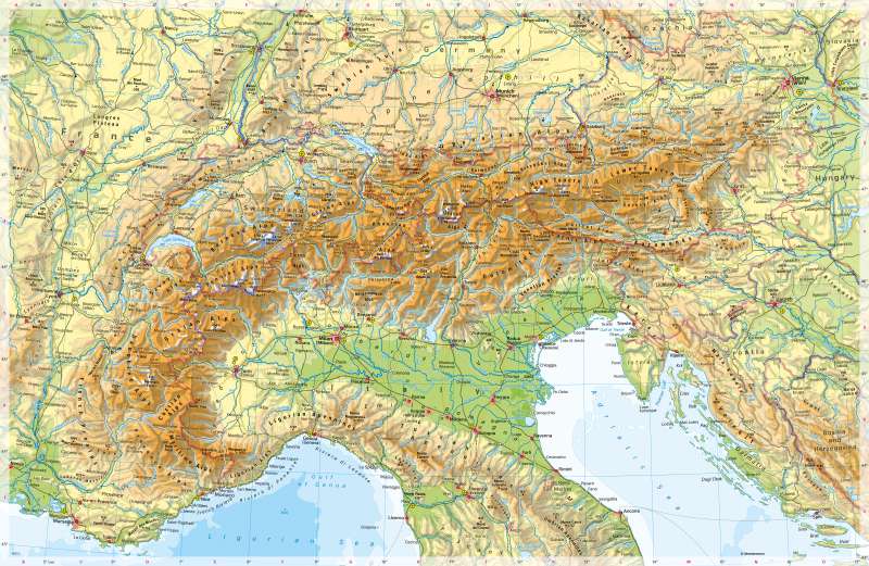
The Alps - Physical map
Physical map
978-3-14-100890-6 | Page 98 | Ill. 1
Overview
The Alps, as highest mountain range in Europe, mark a border between Central and Southern Europe, both climatically and historically. While they are sharply delimited in the south by the Po Valley, they have a relatively broad foreland in the north, the border of which is marked by the Danube and Aare rivers, for example. Characteristic for the Alpine region is the combination of massifs and folded and displaced rock covers. The Western Alps are built up of massifs such as the Mont Blanc massif. In Switzerland, they form two zones separated by the longitudinal valley of the Rhône (including the Aare massif and Gotthard massif). The Eastern Alps consist of three mountain ranges: the Northern Limestone Alps, the Central Alps (Tauern) and the Southern Limestone Alps, each separated by longitudinal valleys (Inn, Salzach, Enns, Drau). In the Western Alps, heights are often between 3000 and 4300 metres, in the Eastern Alps they are generally lower. The highest peak is Mont Blanc (4810 metres) between Italy and France. There are glaciers at high altitudes, but their area has decreased drastically due to climate change.
Countries in the Alpine region
Eight countries share the 1200-kilometre-long Alpine area that stretches from the Ligurian Sea to Slovenia: France, Italy, Monaco, Switzerland, Austria, Germany, Slovenia and Liechtenstein. These eight countries and the European Union (at that time: European Economic Community) signed the Alpine Convention of 1991 for the protection and sustainable development of the Alpine region. To protect the flora and fauna, 13 national parks were founded in the Alpine region (in Switzerland, Italy, France, Germany, Slovenia, Austria).
While in the Alpine foothills megacities such as Milan, Munich and Vienna have emerged, there is no real metropolis in the Alps. The largest city is Grenoble with 160,000 inhabitants, followed by Innsbruck, Trento and Bolzano.
Transport
The Alps are a serious obstacle in trans-European north-south traffic. As the map shows, the small valleys were often starting points for roads and railway lines, which today mainly serve local and regional economic and passenger traffic. They also form the important routes to major tourist areas. Larger transport facilities such as airports, on the other hand, are mostly located outside the high mountain area in the foothills of the Alps (for example Munich, Zurich, Milan, Vienna).
As the Alps lie in the middle of the economically active area of Europe, passenger and freight transport is concentrated on a few, highly developed and busy routes such as the Basel-Bern-Milan-Genoa or the Brenner route Munich-Innsbruck-Verona. The most important transport axis today is the 57-kilometre-long Gotthard Tunnel, a superlative construction that was opened in 2016 after 17 years of construction as the longest railway tunnel in the world. Thanks to its completion, 260 trains (previously: a maximum of 180) and 65 passenger trains can pass through the tunnel at record speed every day. Other Alpine tunnels such as the Mont-Cenis Base Tunnel between Italy and France (also 57 kilometres) and the Brenner Base Tunnel between Austria and Italy are in the planning stage, but it will be decades before they are realised.
