
Cross section of the Earth's crust
The world - Plate tectonics
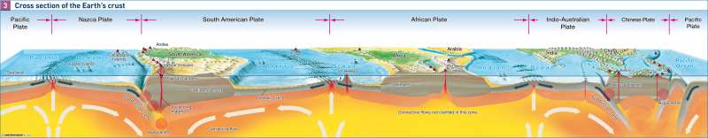
978-3-14-100790-9 | Page 174 | Ill. 3
Information
The continents with their associated shelf zones (0 to 200 m below sea level) form the upper part of the rigid lithosphere. Due to their low physical density they have a large vertical expansion, which explains why they can rise to a great height above sea level. By contrast the high density of the oceanic crust results in only a small vertical expansion, which is why this type of crust only rises above water level in exceptional cases. The old continental cores — such as Greenland, the Australian, African, Canadian, Baltic and Siberian Shields — have an age of up to 4.6 billion years. They have been continental without interruption since the formation of the crust. By contrast the ocean floors, which are continuously undergoing new formation in the mid-ocean rift zones, are nowhere older than 200 million years.The Earth's Structure and Topography
The cause of all these occurrences is assumed to lie in the structure of the Earth. The heat given off by the Earth's interior or mantle penetrates the thin oceanic crust almost unhindered, while beneath the thick continental crusts the heat builds up into a so-called heat tumour, causing the heat to be transferred sideways and thus also leading to horizontally-oriented convection currents and the displacement of terrain.
Research findings of this kind often provide a good explanation for topographical situations. For example in Africa the marginal ridges can be explained as the bulging of the plate edges along former trench zones, comparable to the bulge of the Black Forest and the Vosges along the Rhine trench. Therefore the interior of Africa frequently has the character of a basin landscape with no outflow, where the lakes become converted into salt lakes. Plate drift also makes it possible to explain asymmetrical river networks. In South America the source rivers of the Amazon and Parana rise in the Andes, close to the Pacific, but drain across the entire continent into the Atlantic. The same also applies to Australia. The folding of mountains parallel to the collision line explains the fact that the course of the Indus, Ganges and Brahmaputra is partly directed away from the sea until a gap through to the sea occurs.
Island arcs, formed where a plate boundary converges with the continental shelf zone, divide the oceans into marginal and side seas in the same way as isthmuses, peninsulas and convergent coastlines.
The submarine ridges have an importance that has only recently been recognized in sealing off water masses of varying temperatures between different ocean basins. Only the warm currents flowing near the surface — such as the Gulf Stream — can flow across the oceans and their boundaries, while cold water currents are retained at the boundary. This fact is of importance for the fishing industry on account of the differing oxygen solubility of cold and warm water.
The interlocking of larger ocean areas with the large land masses plays a quite decisive role in the characterization of the climate, because the differing capacity of water and land to store heat leads to more balanced seasonal temperature and precipitation cycles, and the oceanic or continental climate can thus be derived from it.
V. Kaminske; Ü: J. Attfield
