
Three scenarios of future sea level rise in Maloelap
Atmosphere and climate change
978-3-14-100890-6 | Page 21 | Ill. 6
Overview
The Maloelap Atoll lies north of the equator in the Tropical Zone. The prevailing wind direction is northeast due to the trade wind circulation.
Maloelap Atoll
The atoll's land surface is formed by narrow, elongated islands. It is very small: with a lagoon area of 973 square kilometres (slightly larger than Berlin), Maloelap Atoll has only about 10 square kilometres of land area (1400 football fields). Due to the meagre living conditions, remote atolls are only sparsely populated. Around 800 people live on Maloelap. The economic basis is the cultivation of coconut palms and taro as well as collecting marine animals.
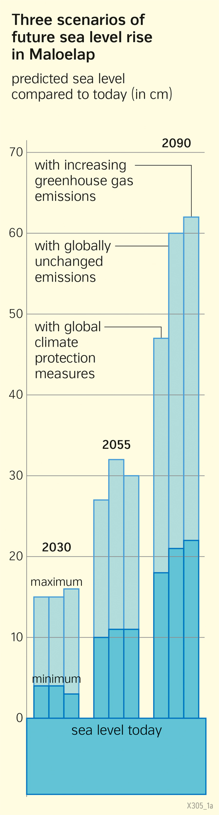
Vulnerability to rise in sea level
The ring of reefs surrounding the lagoon acts like a breakwater. Individual islands stick out one to four metres above the high tide line. The low elevation above sea level explains the vulnerability of the atoll and its inhabitants to sea-level rise. There is a danger that the growth of the reef will not be able to keep up with the sea level rise. Then the reefs can no longer perform their function as breakwaters, increasing the risk of flooding during storms. Areas that are now up to 70 centimetres above sea level could even be permanently flooded by the end of the century.
