
London
London and Paris - Global cities
978-3-14-100790-9 | Page 68 | Ill. 2
Information
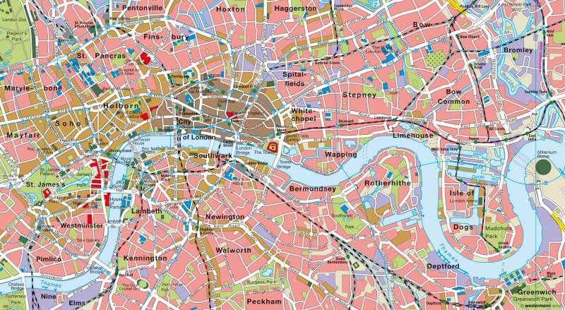
The map shows the functional structure of most of Central London and the western parts of the Docklands on the Thames. The scale of the Roman settlement, which later formed the historic core of the metropolis, was located in and identical to, the approximate area of the "City of London". The paramount importance of this district, as one of the world's major economic centres, has increased in recent years, with on-going interior re-organisation and structural alterations.Central London
The area between the inner city and the traditional, political centre of Britain (the borough of Westminister) is intersected by shopping streets, residential and office districts with considerable amenities. These areas are the main focus for visiting tourists in addition to the royal palaces in the St. James area, as there are numerous government buildings (mainly Westminister Parliment and various diplomatic embassies in Mayfair). In nearby Soho, a large number of theatres can be found. Nearby, Marylebone offers many hotels and retaurants. A sizable proportion of Central London is covered by parks. A number of historic buildings can be found situated in the public parks.
While numerous public parks have emerged in the vicinity of the Thames north bank, the preferred residental areas are more to the south of the river. The working class neighbourhoods are typically in the east of London. Some of these neighbourhoods are now outdated and structually characterised by racial segregation.
For decades, London's inner city was one of the most polluted passenger transport areas in Great Britain. In 2003, the congestion zone was still east of the toll free streets of Park Lane, Grosvenor Place and Vauxhall Bridge. In 2007, the "congestion zone charge" extended to the western boroughs of Westminister, Kensington and Chelsea. Apart from the mentioned thoroughfare, one is only allowed to drive through the area after paying a toll/charge of eight pounds (around 11.20 euro) per day. According to official figures, the charge has resulted in a decrease of between 15 to 20 (or almost 20%) percent in the amount of congestion on the roads. Traffic accidents and environmental pollution have decreased and in parallel, the numbers of cyclists and the use of public transport have increased.
Structural Changes in the Port Area
Nowhere in London has development in the last two decades been as drastic as in the Docklands, with its tower located east of the port district. The outdated central parts of the port facilities (partly dating from the early 19th Century) were shut down due to increasing competition from other British and European ports. This was also because of the lack of investment interest from local firms between 1967 and 1981, and especially because many outsized cargo and container ships that were landing could no longer be cleared. Tens of thousands of the workforce, who were previously employed at the "upstream docks"; or working for the port-orientated firms that had been busy, then became unemployed. The Docklands developed socially into an inner-urban problem area.
Since 1981, the infrastructure has been renewed and partially rebuilt from scratch. Part of the Isle of Dogs has been declared an " enterprise zone" where companies (mainly from the light industry field) looking to set up there, receive special planning permission and receive tax benefits. In the entire Docklands area, new residential areas of architectural diversity have been developed with residences situated directly near the shore of a higher price range. Old warehouses have been converted into new luxury apartments or offices and water-related recreational facilities have been opened in different locations. An architectural flagship of the revitalisation, which has changed London's skyline, was the development of the Canary Wharf tower on the west side of the Isle of Dogs. The developed transport infrastructure and the City have been linked to the Docklands by the Docklands Light Railway running on stilts. At first, serving as an extension to the Isle of Dogs area and outsourcing area for City use, due to the high concentration of the financial services there, it has also become a competition centre to the City of London.
With the focus of the commercial water and strand areas in the Docklands, which have also towered above the old industrial sites along the Thames with new offices, commercial and residential for free use. At the same time, the whole of the South Bank has established itself. Since the 1970's, the Tate Gallery at Vauxhall Bridge, the London Eye in front the Old County Hall, the Royal Festival Hall, the National Theatre and Globe Theatre, as well as the Tate Modern in the Southwark, have established the South Bank with a reputable image with its ensemble of cultural institutions. Even the ambitious Millenium Dome, which was already written off in 2001 as a financial disaster, is to have a new use as a site during the Olympic Games in 2012.
A: H.-W. Wehling; Ü: Colette Fleming
