
Last ice age
Europe - Physical
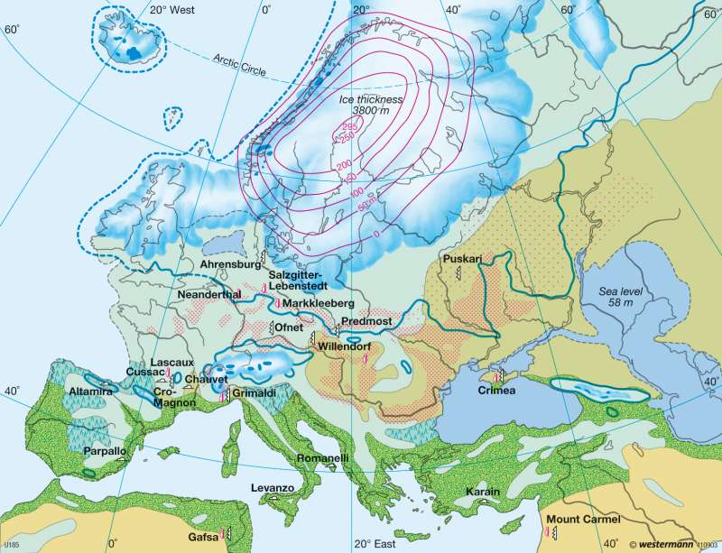
978-3-14-100790-9 | Page 26 | Ill. 1
Information
The map shows the continent of Europe during the last glacial period roughly 20,000 years ago. Mean temperatures 4 to 8°C lower than those of our century caused massive advances of Alpine glaciers and movements of Scandinavian inland ice masses toward the South. These profound climatic changes resulted in a shift of climate and vegetation zones toward the Equator. Tundra became predominant in Western and Central Europe, while boreal coniferous, deciduous and mixed forests covered much of the Mediterranean region. Fine calcareous dust composed of a variety of minerals substances and referred to as loess was blown from inorganic deposits created by the ice, such as moraine and gravel fields and periglacial rubble accumulations. Despite the inhospitable living conditions, human communities of hunter and gatherers lived in Europe during this period of the Stone Age.Surface forms of the last glacial period
The last glacial epoch, known as the Pleistocene, began more than 2,500,000 years ago and ended with the deterioration of the solid ice cap formed during the Weichsel-Würm glacial period, which still covered large portions of the Scandinavian mountains some 9,000 years ago. The four most recent glacial periods in the northern Alpine Foothills are named for rivers and referred to as the Guenz, Mindel, Riss and Würm periods.
A glacial period corresponding to the Guenz glacial has not been identified with certainty in northern Germany. Subsequent glacial advances during the Elster, Saale and Weichsel periods presumably obliterated these early traces of glaciation.
The major glacial advances of the Pleistocene epoch had a significant impact on the topography, with noticeably different effects in northern Germany and the Alpine region. In the Nordic glacial, the ice masses advancing from Scandinavia moved accumulations of fine and very coarse material, including foundlings. These accumulations were reformed by erosion and glacial valleys. Large portions of the pre-glacial topographic relief were covered by morainic rubble.
In the Alps, glaciers had a clearing effect which created the characteristic Alpine relief. The downward shift of the climatic snow line promoted the expansion of valley glaciers, the tongues of which also covered the Alpine Foothills. Terminal moraines mark the farthest points of glacial advance today.
Exhibiting a basic pattern similar to that of northern Germany, a remarkably regular accumulation of forms known as the glacial series took shape in the Alpine Foothills. During each period of glacial advance, ice spread over the deposits left by the last preceding glacial period. A basal moraine pushing rubble ahead of itself accumulates beneath the glacier. A terminal moraine is formed along the ice margin (interstadial epoch), with rubble fields (outwash plains in northern Germany) deposited by meltwater in front of them. The picture was completed by drainage gullies (glacial valleys in northern Germany), in which glacial meltwater was captured. In northern Germany, these merged with the water from streams coming from the South and flowed along the ice margin to the sea.
D. Sajak; U: J. Southard
