
The Earth's mantle
The world - Plate tectonics
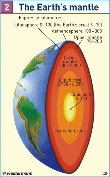
978-3-14-100790-9 | Page 174 | Ill. 2
Information
The continents and their associated continental shelves (0 to 200 m under sea level) form the upper parts of the solid lithosphere. Due to their low physical density, they exhibit a large vertical expansion which is why they tower far above sea level. In contrast, the high density of the oceanic crust results in a slight vertical expansion. This type of crust only protrudes above sea level in exceptional cases. The old continental cores; notably Greenland, the Australian and African Plates, the Canadian, Baltic and Siberian Shields; are up to 4.6 Billion years old. There has continuously been mainlands since the formation of the continental crust. The ocean floors, which are constantly being created in the mid-oceanic rift zones, are no more than 200 million years old.Crust structure and Topography
The cause of all these aspects will be assumed in the structure of the crust: The heat emission from the inner earth (i.e. the mantle of the Earth), takes place almost unhindered by the straticulate ocean crust. However, the thick continent crust blocks up the heat underneath to a so called heat tumour and creates a sideways heat dissipation. Thereby, horizontally generated convection currents and displacement of terrains occurs.
Such research findings allow for different explanations for topographic conditions. For instance, they explain the borders in Africa as an arching slab along the former rift zones, comparable to the arching of the Black Forest and Vosges along the Rhine rifts. This helps to sustain the inner prevalent character of Africa's drainage basin landscape, transformed to salt lakes. The plate drifts also allow further explanation of an unsymmetrical hydrography: In South America, the head waters from the Amazons and Parana in the Andes near the Pacific, dehydrate over the collective continent into the Atlantic. The same is also true for Australia. The folding of the mountains parallel to the collision line partly explains the sea course from Indus, Ganges and Brahmaputra, until it breaks out into the sea.
When divided into the shelf area of advanced plate boundaries, island arcs of the oceans and seas, as well as in peripheral isthmus, peninsulas and coastal paths converged.
The submarine ridge has a recently recognised importance in the warm bulkheading waters between different ocean basins. Only shallow, flowing warm water currents, like the gulfstream, run their swells across the seas, whereas cold water currents grip to swells. This statement holds because of the different oxygen solubility of cold and warm water, which is important for the fishing industry.
The connection of the larger expanses of water, with the large land masses, plays a crucial role in the characterisation of a climate. This is due to the different heat storage capacity of water and land, balanced by the annual course of temperature and precipitation. Therefore, oceanic and continental climate can be derived.
V. Kaminske; Ü: Colette Fleming
