
The world — Physical map
The world - Physical
978-3-14-100790-9 | Page 172 | Ill. 1
Information
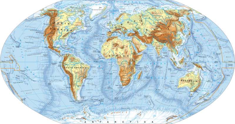
The continents and their associated continental shelves (0 to 200 m under SL / sea level) form the upper parts of the solid lithosphere. Due to their low physical density they exhibit a large vertical expansion which is why they can tower far above sea level. In contrast the high density of the oceanic crust results in a very slight vertical expansion, this is why this type of crust only protudes above sea level in exceptional cases. The old continental cores — notably Greenland, the Australian and African Plates, the Canadian, Baltic and Siberian Shields — are up to 4.6 Billion years old. They have (continuously) been continents/mainland since the formation of the continental crust. The ocean floor, which is continuously being created in the mid-oceanic rift zones is no more than 200 million years old.The Evolutionary History of the Earth
The Geoscientific analysis of the evolutionary history of the Earth sets this age difference. It examines the preceivable structures of the ocean floor; for instance fault transformation of the characteristics of island arche rift zones, subduction and rift zones, also terraines and welded extrinsic clods; and try with help paleological-measurement and other methods that to clarify the cause of Geodynamics.
A few preliminary results of these researches include:
— Although the continental mass almost always remains above sea level, the continental shape, continuously changes through detachment, drift and accretion.
— By theoretically retracing the (movement of the) continents on the basis of their magnetic field lines it was possible to reconstruct an ancient supercontinent / continental land mass called Pangaea with interrelated, magnetically parallel field lines.
— The continents and plates are not identical. Mostly, the continents and the oceanic crust, which has been (newly) created after continental break up, form a plate together. Therefore there are mainly composite plates, however pure oceanic plates like the Pacific Plate also exist.
— Mountain ranges always mark a seam between two plates, whereby mountain ranges located at active continental margins indicate an ongoing subduction and inner-continental mountain ranges, such as the Ural or the Appalachians, are evidence of a process of collision and compression in earlier geographical periods.
The time of a continental break/drift can be determined with the help of radiometric dating of the oceanic crust.
— with the "sea floor spreading"; hikes the continental clods separated through the break of the centre itself of dissolving big continent (apart from backs of the plates) the spread of the deep sea floor, arching of the ditch edges, formation of middle-oceanic ridges.
— North America and Eurasia amalgamated in the Paleozoic Era, as the course of the Caledonian chain — with the Appalachians, east Greenland, Scotland and Norway; shows. Rock examinations have also proved that both Florida and large parts of Italy have their origin in North Africa. This would mean that North America and Eurasia are terrains.
— Oceanic ridges; for example the Walvis Ridge, the Guinea Ridge, the Sierra Leone Ridge and the Para-Schwelle in the Atlantic, the Hawaii Ridge, that of Sala y Gómez Ridge and the Kiritimati Ridge in the Pacific or the Bengalese Ridge in the Indian Ocean; form a trail of mantle-induced hotspot-volcanism.
— With the finiteness of the Earth's surface, the formation of a new big continent elsewhere is to be expected in a geologically foreseeable time, in which the drift plates weld together one on top of the other to produce new mountains and volcanoes.
V. Kaminske; Ü: C. Fleming
