
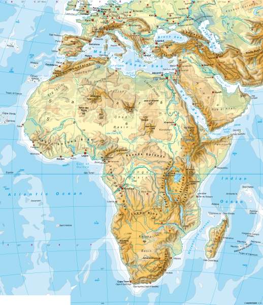
Africa — Physical map
Africa - Physical
978-3-14-100790-9 | Page 153 | Ill. 4
Information
The physical map of Africa outlines the continent's numerous contrasts as well as unique natural regions. It also shows the basic structure of settlements such as the populated central areas of the Sahara.Northern Africa
The map demonstrates the large dry areas of northern Africa and western Asia and rivers such as Senegal, Nile, Niger and Chari as lifelines for these regions. Together with the coasts, they are focal points of settlements in the north of the continent. South of the Sahara, the settlement pattern is more consistent in the alternating and continuously humid tropics.
The relief in the interior of the continent is divided into basins and ridges over a wide area. The water system is geared to the basins (see; rivers to Lake Chad, Upper Nile Basin (Sudd) and the Congo Basin). Wadis and salt pans are examples of the typical geometric shape of large deserts. What is striking is the former dotted outline of Lake Chad, which has lost much of its surface due to anthropogenic influences and persistent drought. Each year, the shoreline of the very shallow lake shifts or changes according to the amount of rainfall and inflow in the region. Another striking scene is the inland delta of the Niger, south of Timbuktu in Mali. It is characterised by the seasonal floods of the Niger and its tributaries, as well as a widely-branched river network.
The greatest heights in northern Africa are reached in the eastern highlands and mountain regions and in the Atlas Mountains, as well as the central mountains of the Sahara (Ahaggar, Tibesti). The highlands of Ethiopia connect the East African ridge system with the Red Sea.Southern Africa
Almost the entire south and east of Africa is at a relatively high altitude (high Africa). Larger planes only exist on the east coast at the Indian Ocean.
The south of the continent is formed from very old and tectonically quiet plates. It is divided into basins and ridges (e.g. Lunda Ridge and Kalahari Basin), where the mountain borders of the basins are sometimes very high (e.g Drakensberg Mountains). This eastern sub-space faces to highlands and trench structures which are affected by active tectonics.
The surface structures follow the river networks (basin of the Congo River system, rift valley lake chains, in the Kalahari Basin: Wadis and Cubango river ending in an inland delta). What is also striking is the contrast between the east and the west coasts (see notes), which is caused by very different climatic conditions. While the east coast is windward side of trade winds and has regular, high rainfall, the west coast is in parallel dominated by wind currents and the cold Benguela current, resulting in very little rain fall.
The greatest heights in the south of the continent are reached by Kilimanjaro and the other large volcanoes of eastern Africa such as Drakensberg. Madagascar and the surrounding island groups form a separate sub-space.
M. Felsch
