
Central Valley (California) — Mixed intensive agricultural at Diener Farm (Fresno County)
U.S.A. - Past and present
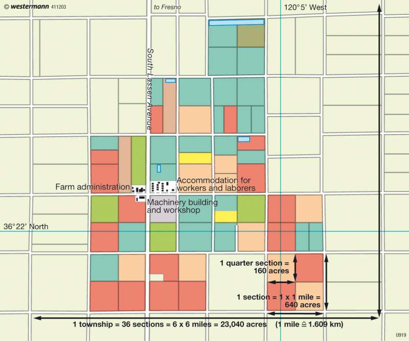
978-3-14-100790-9 | Page 137 | Ill. 6
Information
California's Central Valley is situated between the cities of Redding in the north and Bakersfield in the south. The northern part is the Sacramento Valley, while in the south is the San Joaquin Valley. The region favourable for agriculture is bounded in the west by the coastal chain and in the east by the Sierra Nevada, which rises to 4,421 metres at its highest peak, Mount Witney. Fresno County with the city of Fresno as its centre lies approximately in the middle of the San Joaquin Valley. Here the favoured crops are cotton, lettuce, tomatoes and wine grown on irrigated land.The Example of Diener's Farm
Diener's Farm is typical of the region: it covers an area of more than 3,000 hectares, whereby the majority of the square or rectangular utilization plots are measured out generously. The plots are arranged in so-called sections of a quarter of a mile or 640 acres, equivalent to some 2.6 square kilometres. The plots mostly correspond to one-quarter of these sections, although some are smaller.
The spectrum of cultivated crops is also typical. The dominant product is cotton, and tomatoes and wheat are also important. Lettuce, maize, garlic and other field crops are grown in smaller areas. The crop proportions change from year to year in response to natural conditions and the state of demand. For example, in 1993 cotton and tomatoes were still grown on more than 75 percent of the terrain. In 2004 this proportion was only 65 percent on account of low cotton prices. Another reason for switching to more wheat cultivation in 2004 was the fact that cereals need less water. The farmer is also experimenting with the cultivation of almond trees, which he anticipates will offer market opportunities in the long-term.
Without irrigation, based on water allocated by the Central Valley Project (CVP), high-yield farming would be impossible. A number of collecting basins for drainage water can be seen on the map. In recent years, more and more plots have been converted from furrow and sprinkler irrigation to sub-surface drip irrigation, in order to keep the soil from becoming waterlogged as far as possible and to make the most effective use of this valuable resource. In 1985, 63 percent of the area was still under pure furrow irrigation, but by 2002 this proportion had already fallen to 24 percent. In the same period, combined furrow and sprinkler irrigation rose from 15 to 46 percent and drip irrigation rose from 1 to 18 percent.
This makes modernization of the entire cultivation necessary. To protect the sub-surface irrigation installations from damage, their locations are coded with GPS data so that they can be recognized by every tractor driver on their computer. Despite all rationalization measures, a farm of this size requires many workers. The map shows the relatively large area, alongside the main farm building, that is required for workers' housing.
D. Falk; Ü: J. Attfield
