
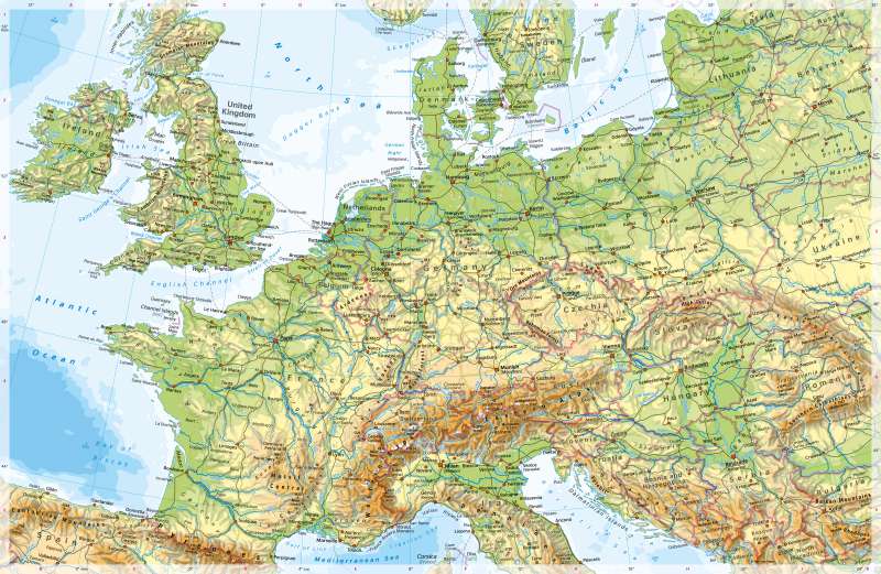
Western and Central Europe - Physical map
Physical map
978-3-14-100890-6 | Page 88 | Ill. 1
Overview
In terms of geological structure, western Europe consists of three units. The oldest rocks are found in the area of the Caledonian Mountains in the north. The area of the Benelux countries, Great Britain (with the exception of the southwest) and Ireland (with the exception of the south) can be assigned to this area. Mountain building here began in the Ordovician and reached its peak in the Silurian, approximately 400 million years ago. Today, the mountains of Caledonian origin are strongly eroded, in the south also covered by Mesozoic sedimentary layers. Therefore, there is a contrast between the landscapes of south-east England and the low mountain ranges of the Pennines, the Scottish Highlands and the Grampian Mountains. The highest mountain there is Ben Nevis (1343 m).
Variscan and alpine mountain folding
To the south, one can find a vast area whose formation is linked to the Variscan mountain building in the Devonian and Carboniferous periods 300 to 400 million years ago. It includes the the rest of Western Europe with the exception of the younger Pyrenees. The mountains formed at this time have largely been eroded. Because of this, today, France consists of extensive flat to hilly lowlands, basins and tablelands, which are bordered by the Atlantic and the Mediterranean, by the Pyrenees, the Alps and the Vosges. Only the Massif Central and the Cévennes in the south are mountains that reach greater heights (Puy de Sancy, 1886 m).
The geologically youngest rocks in Western Europe are found in the Pyrenees. Their formation took place at the same time as the Alps were created (Alpine mountain building in the Tertiary, peak of uplift about 20 million years ago). With heights of up to 3404 metres (Pico de Aneto), the greatest heights in Western Europe are reached there. The Pyrenees form the link between Western Europe and the Iberian Peninsula.
The wide rift valley between the Vosges and the Massif Central in the west and the Jura and the Alps in the east, followed by the Saône and Rhône rivers, is also geologically young.
Special features
- The map shows numerous examples of the typical delta-shaped (on the Rhine/Meuse, Rhône) as well as funnel-shaped (for example Seine, Thames, Elbe) river mouths.
- The Eurotunnel under the Strait of Dover connects Calais (France) and Folkestone (England) by rail and road.
- Greenwich near London is crossed by the prime meridian, a central orientation line in the Earth's grid of degrees.
- Guernsey and Jersey are examples of Channel Islands that do not belong to Great Britain but are directly assigned to the British Crown.
- The Netherlands is an example of a country where the capital (Amsterdam) and seat of government (The Hague) are not identical.
- Ireland and Great Britain, because of their insularity, have no land borders with third countries, only with each other.
Settlements and transport
Western Europe is densely populated and covered by a dense transport network. In many places it is determined by its orientation towards the sea. The coasts are strongly indented by bays and have numerous natural harbour areas. The Strait of Dover is one of the busiest shipping passages in the world. In many areas, the distance to the sea is less than 200 kilometres, with the exception of eastern France. The funnel- or delta-shaped mouths of the large rivers are also striking. These are often the main points of settlement and traffic, for example along the Seine and the Rhone as well as the Rhine.
Due to their economic, political and cultural importance and their position in the transport network, the two global cities London and Paris stand out in particular. They are to be classified as Primate Cities of Great Britain and France. Western Europe is also the centre of the European Union, with Brussels, Luxembourg and Strasbourg as the three main administrative centres.
