
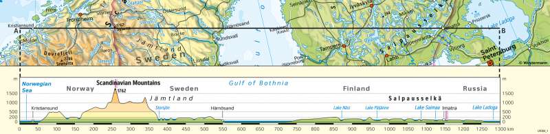
Terrain profile
Physical map
978-3-14-100890-6 | Page 77 | Ill. 3
Overview
The elevation profile of Scandinavia describes the elevation Kristiansund on the west coast of Norway to Imatra in the east of Finland.
From the European North Sea to the Skanden mountains
Kristiansund is located directly on the European North Sea and thus only just above sea level. Behind it, the Skanden mountain ranges begin, which stretch to the west and northwest of Norway. The highest point of the Skanden is reached at 1762 m and lies about 200 km from the Norwegian west coast. This highest point also marks the border with neighbouring Sweden. The end of the Skanden is reached about 350 km from the west coast.
From the Skanden mountains to Lake Lagoda
From the Skanden mountains to Lake Lagoda
At the eastern foothills of the Skanden Jämtland, which extends to Härnösand on the Gulf of Bothnia, begins. The landscape of Jämtland is predominantly hilly. This is followed by the lake landscape of the Storsee. This is a collection of several interconnected lakes. At this point, an altitude just above sea level is reached again. The highest point in the Jämtland region is about 50 km west of Härnösand and reaches an altitude of just over 200 metres. The landscape slopes down again to the Gulf of Bothnia. The town of Härnosand itself is only about 100 m above sea level. The Gulf of Bothnia stretches for about 200 km from Härnösand on the western shore to the eastern shore. This is where Finland begins. The landscape of Finland has only slight differences in altitude and numerous lakes are scattered in that area. The eastern shore of the Gulf of Bothnia is just above sea level (about 100 m above sea level). Afterwards, the landscape rises slightly to the shore of Lake Näsi (approx. 200 m above sea level), only to drop again to approx. 100 m above sea level. The landscape continues in a similar way for about 300 km, until finally the town of Imatra on the Finnish-Russian border is reached and after another 100 km Lake Ladoga.
