
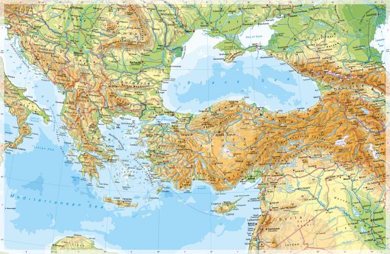
South Eastern Europe - Physical map
Physical map
978-3-14-100890-6 | Page 104 | Ill. 1
Overview
Southeast Europe, the eastern Mediterranean and the area of Turkey have almost fully retained their shape during the phase of young alpine orogenesis, which began at the turn from the Lower to the Upper Cretaceous about 90 million years ago and reached the highest activity of uplift about 20 million years ago. The mountain ranges have a high-mountain character in their highest areas.
Folding phases
The Carpathians and the Jaila Mountains on the Crimean Peninsula to the north of the Black Sea border the Eastern European Lowlands to the south. Narrow coastal fringes lead from the mountain ranges to the Mediterranean Sea and its marginal seas (Aegean and Adriatic Seas with groups of small islands) as well as to the Black Sea. The approximately 5,000 islands in the eastern Mediterranean are striking. The two largest islands are Cyprus and Crete. They each cover about half the area of Saxony. The comparatively very shallow Sea of Azov is about as large as Hesse and Thuringia combined.
Special features
- The highest mountain on the map is Mount Elbrus (Caucasus, 5642 m high). The high altitudes of the Caucasus are glaciated.
- The large natural lakes in Anatolia, eastern Turkey and Iraq are salt lakes.
- Wadis as well as lakes with variable shorelines are depicted on the Arabian Peninsula.
- In the map, examples of the typical river mouth shape of the delta can be seen (Danube, Volga, Kuban).
- The Mediterranean region is home to numerous ruins, such as Babylon, Troy, Pergamon and Olympia.
- Greece comprises 3504 islands, which together account for about one fifth of the country's surface area. Important ferry lines run between the Greek islands.
- Very large dams can be seen in eastern Turkey and Syria. They regulate the water balance on the Euphrates and Tigris rivers and enable agricultural irrigation systems.
- The Bosphorus, which is heavily trafficked by ships, connects the Black Sea and the Mediterranean. It is about 30 kilometres long and less than one kilometre wide at its narrowest point.
- The Iron Gates lies in the valley where the Danube passes through the Carpathian Arc. Serbia and Romania have built a dam there to enable safe shipping. They also operate hydroelectric power plants there.
Settlements and traffic routes
The settlement history of the eastern Mediterranean is very long. Today, the coasts stand out as preferred settlement areas, although not as intensively as in the western Mediterranean. It is striking that the capitals, with the exception of Athens, are nevertheless located inland and at a greater distance from the sea.
With around 15 million inhabitants, Istanbul is the second largest metropolitan region in Europe after Moscow and ahead of London, Paris and Rhine-Ruhr. The Bosporus, a strait only 2.5 kilometres wide at the most, forms the border between Europe and Asia, which leads to Istanbul lying on two continents. Its special location at the crossroads of the Black Sea-Mediterranean shipping route and the land route between West Asia and Europe has had a significant influence on the city's history.
