
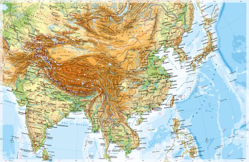
South Asia and East Asia - Physical map
Physical map
978-3-14-100890-6 | Page 130 | Ill. 1
Overview
South Asia extends south of the inner Asian high mountains and highlands between the Arabian Sea in the west and the Bay of Bengal in the east. It comprises the Indian subcontinent including the island of Ceylon. The map also shows the mountain ranges that frame the Indian subcontinent in the west, north and east (Himalayas) as well as large parts of East Asia up to the Pacific Ocean. Politically, South Asia includes the states of Pakistan, India, Bangladesh, and Sri Lanka. The subcontinent is divided into the Hindu Kush, Karakoram and Himalayan foothills, the Indus and Ganges-Brahmaputra lowlands, mountainous central India, and the Deccan Plateau, which are bounded by the steep Western Ghats in the west and the Eastern Ghats in the east.
In the north, the Indian subcontinent is bordered by the high mountains of the Hindu Kush, Karakoram, and Himalayas. They extend over a length of several thousand kilometres. With Mount Everest (8848 m) and K2 (8611 m), the highest peaks on earth are located here.
Major geographical units of China
East Asia is largely occupied by China. The country has a share in seven large landscapes: In the west, these are the highlands of Tibet, the great basins in the northwest and the Mongolian highlands, all of which are arid areas. To the east, there is Manchuria and the large landscapes of North and South China, which are separated from each other by the complex mountain system of Central China.
In fertile northern China lie the Great Plain, which was filled in by the Huang He, and the Loess Plateau, which adjoin it to the west. Southern China is largely made up of low mountain ranges and basin landscapes, including the fertile Red Basin formed from reddish sandstone sediments. The southernmost point of China is Hainan Island in the South China Sea (apart from the territorially disputed Paracel Islands).
Special features
- Mount Everest, at 8848 m, is the highest mountain in the world on China's border (Tibet) with Nepal.
- The lowest location on the map is 10 540 m east of the Philippines in a deep-sea trench.
- The high altitudes of the Himalayas and other mountains are glaciated.
- The Mekong is the tenth longest river in the world with 4500 kilometres, the Huang He the eighth longest with 4845 kilometres and the Yangtze River the third longest with 6380 kilometres.
- The Qinghai Hu is a drainless salt lake in the northern highlands of Tibet with an area of 4583 square kilometres, which is about 30 percent of the area of Thuringia.
- The Red Basin in China is slightly more than half the size of Germany and owes its name to the colour of its fertile soils.
- The Turpan Depression is China's lowest point at -154 metres and is enclosed by the eastern foothills of the Tian Shan.
- The Tarim Basin lies as a drainless basin between the mountain ranges of the Tian Shan, Pamir, Karakorum and Altun Shan. Seasonal rivers and salt pans can be seen in it.
- Karakorum, capital of the Mongolian Empire from the early 13th century onwards, is recorded as a ruined site. The ruins of the medieval city of Char Choto, once a flourishing trading centre, lie in the west of the Gobi Desert.
- Border disputes over the Kashmir region exist between China, India and Pakistan.
- Taiwan (officially "Republic of China") is considered as part of its territory by the People's Republic of China. Taiwan is only recognised diplomatically by about 20 mostly small states worldwide. Most countries, including Germany and the USA, only maintain unofficial representations.
- There is a territorial dispute over the southern Kuril Islands (with Kunashiri and Etorofu). They have belonged to Russia since 1946 but are claimed by Japan.
- On the Yangtze River near Yichang is the Three Gorges Dam, a controversial large-scale project to generate energy and promote shipping. The dam is about 600 kilometres long, which equals the distance Hamburg - Munich (as the crow flies).
- Russian space flights (cosmodrome) take off from Baikonour (Kazakhstan).
