
South America - Physical map
Physical map
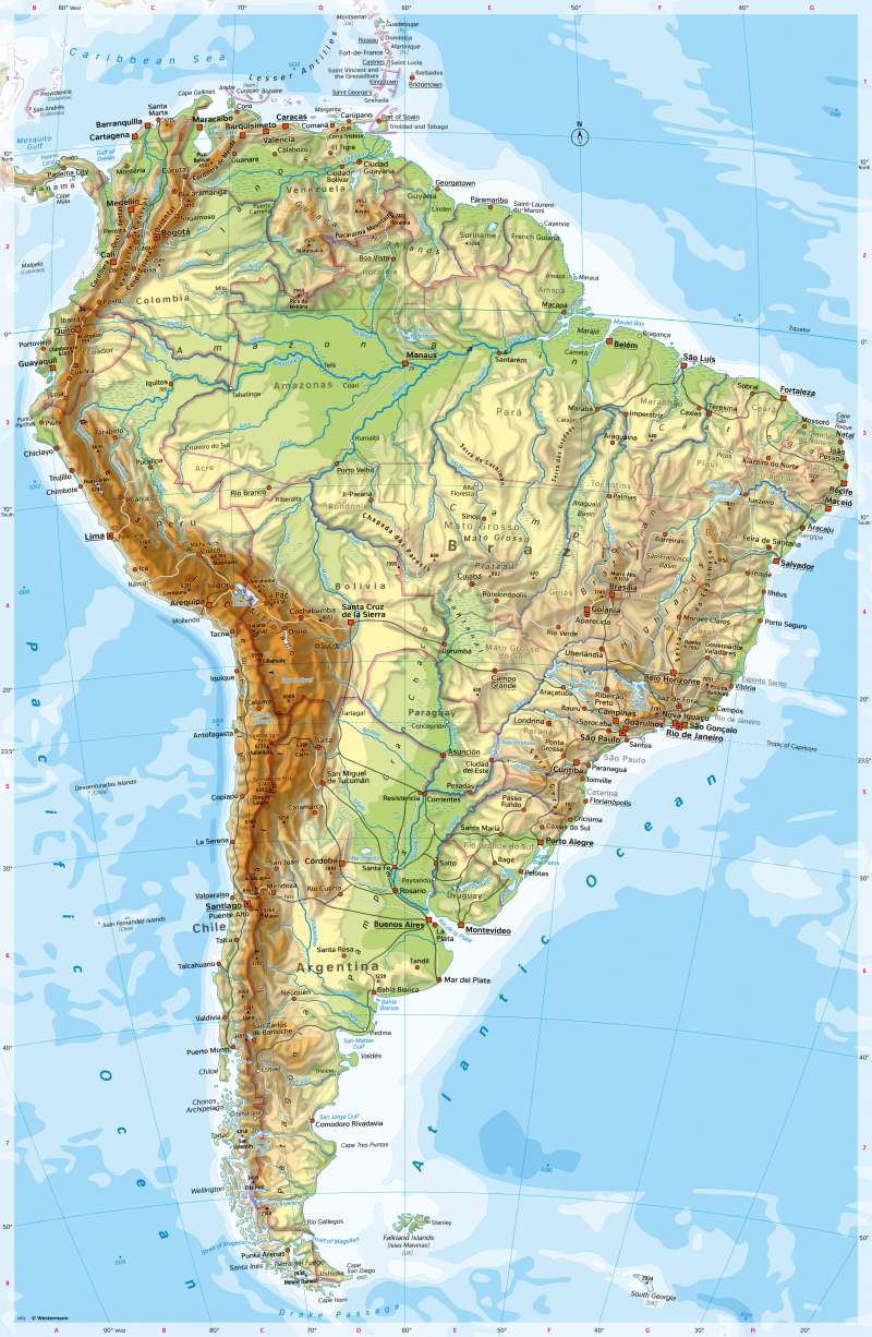
978-3-14-100890-6 | Page 192 | Ill. 1
Overview
In terms of geological structure and surface, South America is very similar to North America. However, the climate and vegetation are very different.
In the west, the young mountain ranges of the Andes with their almost 7000 metre high peaks are among the highest folded mountains in the world. The Andes are made up of numerous parallel chains, separated by longitudinal valleys. In the north, they form a curved line in the shape of a mirrored "S", which changes to a north-south direction with a clear bend at about the 15th southern longitude.
In the area of the Peruvian-Bolivian Altiplano, the Cordillera reaches its greatest west-east extension with a width of 700 kilometres. Lake Titicaca is located there at an altitude of 3812 metres. Several young volcanoes such as the Ojos del Salado, at 6880 m the second highest Andean peak, bear witness to ongoing tectonics. This is also indicated by the deep-sea trench running parallel to the coast in the Pacific Ocean, only about 100 kilometres from the coast.
The Andes run towards the south to the mountains between Chile and Argentina and the islands of Tierra del Fuego. In geological terms, they continue in the Antarctic Peninsula. Towards the north, they continue in the high mountains of Central America, the Sierra Madre and the Rocky Mountains.
Major geographical units east of the Andes
South America, east of the Andes, consists essentially of old or folded-over land masses that once belonged to the huge continental mass of Gondwana. Rising from vast plains, basins and lowlands are the Guiana Highlands and the Brazilian Highlands. While the Amazon lowlands stretch between these two highlands, the Orinoco basin separates the Guiana highlands from the Andes.
Between the old highlands in the east and the young folded mountains in the west, wide basins span the interior of the continent, into which thick layers of sediment have been deposited since the Andes folded up. Striking landscapes are the Gran Chaco and the Pampa.
Special features
- The highest mountain on the map is Aconcagua between Santiago and Buenos Aires (6961 m).
- In the dry plains of Argentina, there are salt pans, a salt lake and seasonally flowing rivers.
- The coastal forms in southern Chile are reminiscent of the fjord coasts of Norway. The coastal mountains there are glaciated.
- Lake Maracaibo in Venezuela is almost as large as Thuringia. It is connected to the Caribbean Sea via the Gulf of Venezuela.
- Lake Titicaca is one of the highest lakes on earth. It is about half the size of Schleswig-Holstein and is navigable. The border between Peru and Bolivia runs through Lake Titicaca.
- In the Andes, sites of Indian advanced civilisations can be found (including Macchu Picchu, a ruined city of the Incas in present-day Peru).
- The Strait of Magellan was navigated in 1520 by the Portuguese navigator Fernão de Magalhães, the first European to do so. During the crossing, the sailors saw numerous fires on land at night. They therefore gave the islands south of the Strait of Magellan the name "Tierra del Fuego".
- Paraguay and Bolivia are landlocked states.
- In the map, there are numerous examples of borders running along rivers (in Paraguay, Uruguay and Colombia, among others) or on mountain ridges (Chile and Argentina).
- French Guiana is slightly larger than Bavaria. The European Space Agency operates a spaceport there.
- In the Caribbean, there are some small islands that belong to France, Great Britain and the Netherlands respectively. In the south of the continent are the Falkland Islands, the subject of armed conflict between Great Britain and Argentina in 1982.
- Numerous rivers are dammed in the Brazilian mountains. They form the basis for hydroelectric power generation, which is economically very important for Brazil.
- The greatest depth in the map is off Antofagasta (-8066 m). A deep-sea trench runs parallel to the coast there.
- There is a river bifurcation (the water of a river flows into two different river systems) between the Orinoco and the Amazon or Rio Negro.
