
Russia and Central Asia - Physical map
Physical map
978-3-14-100890-6 | Page 110 | Ill. 1
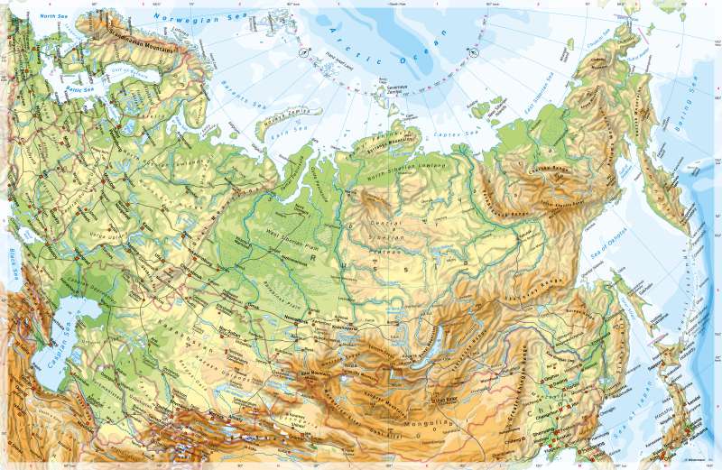
Overview
The map shows the north of Eurasia, from Central Europe in the west to the Bering Strait in the east, from the Arctic Ocean in the north to the great mountains of Central Asia. This area is largely identical with the territory of Russia, the largest country on earth by area. Russia comprises eleven time zones or about 9000 kilometres of east-west extension and about 4000 kilometres of north-south extension. Its area is about 50 times the size of Germany, but the population is less than twice as large. Russia's population is concentrated in the areas to the west of the Urals, with a band extending from the southern Urals via Novosibirsk and Kransnoyarsk to the region around Lake Baikal.
Major geographical units
ds and mountains of North Asia, and the mountainous and highlands of Central and East Asia.
Extensive lowlands and hilly areas determine the surface shape of Eastern Europe. Only in the southeast (Carpathians) and south (Crimea) do mountains that reach greater heights border the Eastern European lowlands. In the south of Eastern Europe lie the Caspian Sea, the Sea of Azov and the Black Sea, in the north the Baltic Sea. There is a broad transition zone to Central Europe.
Within the Eastern European Plain, large areas with heights of around 250 metres stand out. In many places they are covered by loess and are then favourable agrarian areas. The areas north of the plates were glacially deformed during the Weichselian Ice Age. The large rivers flowing through Eastern Europe are just as noticeable as the human intervention in the water network (reservoirs on the Kama, Volga, Don and Dnipro). During winter, the rivers are often frozen for several months.
There is no clear border between Europe and Asia. From a physical-geographical point of view, the Ural Mountains and the Ural River as well as - between the Caspian Sea and the Black Sea - the Kuma–Manych Depression north of the Caucasus form the border. Politically and economically, religiously and culturally, however, large parts of North Asia have been shaped by Eastern Europe - that is where Russia's decision-making centres were and still are.
North Asia stretches from the coasts of the Arctic Ocean to the Kazakh Sill and the peripheral mountains of the highlands and basins of Central Asia (Altai, Sayan, Jablonovy Mountains) in the south. In a west-east direction, it stretches from the Urals in the west to the Pacific Ocean in the east. It is again divided into three parts in terms of its surface shape and formation: In addition to the West Siberian Plains between the Urals and the Yenisei, which date back to the Palaeozoic era, there is the geologically ancient Central Siberian Plateau between the Yenisei and the Lena (low mountains, Angara Shield) and the young chain of mountains east of the Lena, including Kamchatka and Sichote-Alin, some of which have active tectonics. In Western Siberia there are large natural gas and oil deposits (see 112.1 and 115.3).
The islands in the Arctic Ocean as well as the coastal plains created by the sediments of the rivers, which rarely reach larger dimensions, form separate spatial units. Tundras and boreal coniferous forests, in western Siberia also extensive swamps, characterise the area, which, with the exception of the south-east, is only very sparsely populated and hardly developed.
The northern part of Central and East Asia shown on the map is largely occupied by high mountains and highlands as well as desert-like basins embedded in them. A mountain chain rising steeply in many places from the Pamirs to the Tian Shan and the Altai, Western and Eastern Sayan, the Jablonovy, and Stanovoy Mountains separates cold Siberia in the north from dry Central Asia in the south. Only in the west of this chain, there are some mountain valleys that can be used intensively for agriculture, for example the Fergana Valley.
Natural exceptions in East Asia are Manchuria, a favourable agricultural region, and the Japanese archipelago. Towards the coast, the mountains become lower, but still reach significant heights (for example Sichote Alin, 2078 m). The Korean peninsula has a distinctly mountainous character.
Special features
- The highest mountain on the map is Kongur Shan (7719 m).
- Around the northern Caspian Sea, large areas are clearly below sea level (-26 m), the water level of the Caspian Sea is 28 m below that of the world's oceans. Even higher values are reached near Aktau (-132 m) and in the Turpan Depression (-154 m).
- The Caspian Sea has a changing coastline.
- The islands in the Arctic Ocean are largely glaciated, as are the high altitudes of Pamir and Tian Shan.
- Lake Baikal is the largest freshwater reservoir and the deepest inland lake (1637 m) on earth. Its size is comparable to the state of Baden-Württemberg.
- There are huge reservoirs, especially along the Volga.
- In East Asia, the course of the Great Wall of China is partly visible.
- Kaliningrad is a Russian exclave surrounded by Poland and Lithuania.
- There is a territorial dispute over the southern Kuril Islands (with Kunashiri and Etorofu). They have belonged to Russia since 1946 but are claimed by Japan.
