
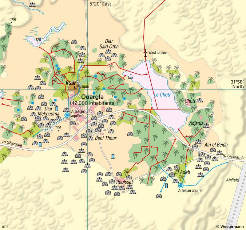
Ouargla (Algeria) - Transformation of a well oasis
Vegetation and agriculture
978-3-14-100890-6 | Page 149 | Ill. 3
Overview
The oasis of Ouargla is located in the north-east of the Algerian Sahara (see map 149.2 â€Sahara and Sahel – Desert landforms and desertification"). Its current appearance is essentially shaped by its importance as a developing regional centre for the development of the Algerian oil and gas fields near Hassi Messaoud, which are located about 80 km east of the city. In addition, typical features of a well oasis can also be found. This juxtaposition of traditional and modern elements can also be seen in the map.
Economy and population
In pre-colonial times, the oasis served mainly as a staging post in the caravan trade and as a marketplace for the nomadic tribes of the area. As late as 1970, there were still numerous tent settlements of the nomads around the town. Today, Ouargla is the administrative centre of the eastern Algerian Sahara. In order to expand the urban functions and create jobs, the state established an industrial estate. State-owned companies and suppliers for the oil and gas fields are located here. Ouargla is also the site of a large military garrison and, since 1988, a university. The city's recent economic development is reflected in its population figures: in 1970 there were around 42,000 inhabitants, ten years later the number increased to almost 82,000. In 1998 there were 129,000 inhabitants and in 2018 170,000 people lived in Ouargla.
Land use changes
The map shows how closely nomadism and the oasis economy were intertwined in the past. The date palm groves of the oasis produced not only dates as a basic food, but also grain and lucerne. The lucerne served as additional fodder for the nomads' camels, sheep, and donkeys. In the palm groves that were established later, fruit and vegetable gardens were also planted. Since 1970, the acreage has increased considerably.
Water issues
With the increase in cultivated area and population, water consumption has risen. The two lakes have almost dried up, and at the artesian well the water no longer reaches the surface. As in many other oases, in Ouargla not only the sufficient provision of irrigation water is important but also drainage (disposal of drainage water). Ouargla is situated in a shallow depression, with extensive salt pans bordering the palm groves. Excess water from the drainage canal and from the sewerage system of the growing city has to be pumped partly through these salt pans into neighbouring depressions to prevent the oasis from becoming swampy. To the north of Ouargla there is an evaporation lake for this purpose.
Spatial development
The historic city centre, the medina, fits the typical North African oriental old town with mosques, souk (central market) and a cul-de-sac street pattern. After many old Berbers moved from the city centre to newer quarters, the medina is now mainly inhabited by black Algerians, the descendants of former slaves of the Tuareg nomads. A business district adjoins the historic city centre to the south. It developed during the French colonial period as a "modern quarter" and took over the trading function of the medina. The neighbourhoods of the more recent city expansion were created together with other housing constructions for newcomers after Algerian independence (1962). The residential quarters of former nomads are also located here. They date back to a programme aimed at settling nomads. The current names of the Beni Thour, Said Otba, and Mekhadma neighbourhoods correspond to the names of nomadic tribes that settled here.
Water issues
With the increase in cultivated area and population, water consumption has risen. The two lakes have almost dried up, and at the artesian well the water no longer reaches the surface. As in many other oases, in Ouargla not only the sufficient provision of irrigation water is important but also drainage (disposal of drainage water). Ouargla is situated in a shallow depression, with extensive salt pans bordering the palm groves. Excess water from the drainage canal and from the sewerage system of the growing city has to be pumped partly through these salt pans into neighbouring depressions to prevent the oasis from becoming swampy. To the north of Ouargla there is an evaporation lake for this purpose.
