
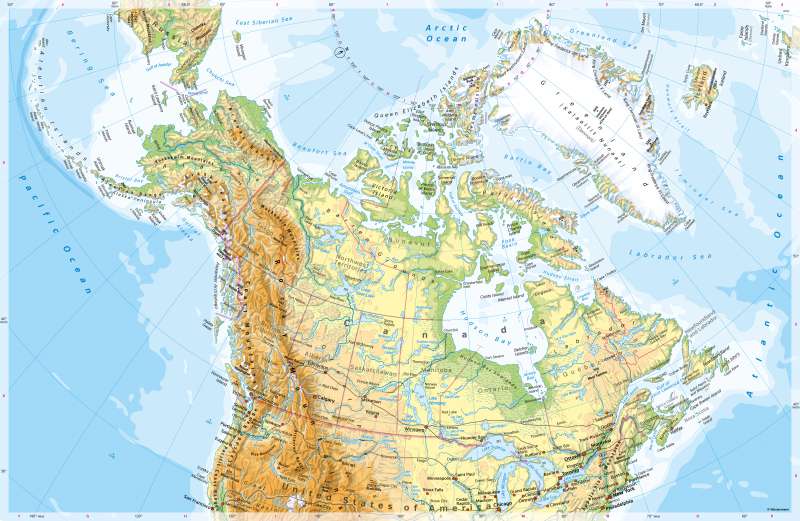
North America (northern part) - Physical map
Physical map
978-3-14-100890-6 | Page 178 | Ill. 1
Overview
The northern part of North America can be divided into four major landscapes:
- Greenland and the islands of the Arctic Ocean,
- the young fold mountains of the Rocky Mountains, the Alaska Range, and the Coast Ranges including the intercalated basins,
- the vast plains and hills of the Great Plains, the Barren Ground, and the Canadian Shield,
- the Appalachian Mountains.
Smaller landscapes with their own character are the island chain of the Aleutians, the flat coastal plains of Alaska (for example, uplifted by the Yukon River) and the islands west of Labrador.
Landscapes of the North
Greenland and the archipelagos in the Arctic Ocean lie to the north-east of America. The natural phenomena and landscape forms determined by the cold climate - for example, glaciers, permafrost, tundras - extend far south on the surrounding land masses. The east coast of Greenland remains mostly enclosed by drift ice in summer, the north-east coast even by pack ice. In the interior of Greenland, the glacier ice piles up to form a plateau over 3000 metres high. The west coast, where the largest settlements are located, is mostly ice-free in summer until north of Thule.
The Polar Zone is affected by the polar day or polar night phenomenon. It extends to the Arctic Circle (66.5 degrees north latitude).
In western North America, geologically young fold mountains running from north to south characterise the landscape. The Alaska Range is the highest of these mountains. The Coastal Ranges and the Rocky Mountains have widespread elevations of up to about 3,000 metres, and even higher elevations to the south. The mountain belts are continued in the south by the Sierra Madre, the high mountains of Central America and the Andes in South America, and by the Alëuten Range in the north. They reach their greatest width in the area of the Great Basin. South of this, there are always large plateaus, highlands and basins interspersed between the mountains. The mountains have a great influence on climatic conditions, as they act as a barrier to the dominant westerly flow of the Mid-Latitudes. On the west coast there are widespread rising rains, while the interior of the mountains is often very dry.
The mountain belt described has been folded in the west onto the geologically old, tectonically stable Canadian Shield. On the one hand, this consists of wide plains, some of which are rich in large lakes and are flowed through by numerous rivers. The largest of these are the Yukon, the Mackenzie, and the Missouri. In the east, the five Great Lakes are connected to the Atlantic Ocean by the St. Lawrence River. On the other hand, the Appalachians also belong to the geologically ancient sub-areas of North America. They are considerably lower than the Rocky Mountains, for example, and have a different natural character due to their naturally closed forestation.
Special features
- The highest mountain on the map is Mount McKinley in Alaska (6194 m).
- Greenland is almost completely glaciated. The island is about 6 times the size of Germany but has only about 56,000 inhabitants.
- Hudson Bay is a relatively shallow marginal sea of the Atlantic Ocean. It is about 3.4 times the size of Germany and about 3 times the size of the Baltic Sea.
- The west coast on the Pacific is highly indented and reminiscent of the fjord coasts of Norway.
- The Great Lakes occupy a total area equivalent to about 70 percent of Germany's land area. The largest of these lakes, Lake Superior, clearly exceeds Bavaria in area.
- In the Arctic Ocean, numerous landscapes are named after European and American explorers who explored the region in the 19th and 20th centuries (including Peary, Amundsen).
- Names such as New York, Québec and Montréal refer to the history of discovery and seizure by European powers.
- The double naming in Northeast Canada and Greenland (for example, Iqaluit and Frobisher Bay, Nuuk, and Godthåb) refers to the indigenous population of the region. Of the approximately 4 million people living permanently north of the 60th latitude, about one fifth are descendants of the indigenous people of this habitat, including Inuit, members of the First Nations or Alaska Natives.
- Niagara Falls are 57-metre-high waterfalls on the border between the USA and Canada, or between Lake Erie and Lake Ontario. There is a bypass canal there for shipping.
- The Great Lakes drain into the Atlantic via the St. Lawrence River. It has been developed as a shipping route with locks, canals and dams. Its length corresponds roughly to the distance Hamburg - Munich (as the crow flies). Ocean-going ships can travel through it far inland.
