
Manchester (England) - Urban development of an industrial city
Industrial Age
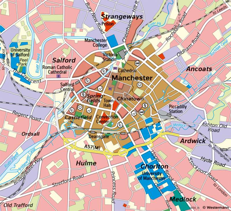
978-3-14-100890-6 | Page 85 | Ill. 2
Overview
The city of Manchester is located in the northwest of England and has about 550,000 inhabitants. In the metropolitan region of the same name ("Greater Manchester") there are almost 3.5 million inhabitants. Manchester can look back on a long history: Founded in the 1st century A.D., the settlement was granted city rights in 1301, the city then received the status of a city ("City Status") in the middle of the 19th century (1853). The map on the left side, which is to be compared with the one on the right from the 2020s, also dates from this time. Two processes can be seen in the maps: Urban development and economic structural change, which is at the same time an expression of a deep upheaval of economic processes. Both processes are interrelated and interdependent.
Historical urban development
The left map shows the urban structures of a typical industrial city of the 19th century. Even though the Industrial Revolution in England began as early as the 18th century and led to changes in social as well as economic structure, the results of this process are still clearly visible in the middle of the 19th century: The driving force behind the development was the Bridgewater Canal, which connected various coal mines from the surrounding countryside to Manchester over a length of about 45 kilometres and was opened in 1761. With these coal transports, the raw material reached the city and could drive steam engines and mills here. Additionally, it could be used in transport to Liverpool. The city itself is structured by transport routes (roads, canals, and railways) and has already grown into the area. The separate parts of the city, divided according to functions, are clearly recognisable: In the centre, there are shopping facilities as well as public buildings, for example the city hall or other buildings of the city administration. There are also various cultural and educational institutions. Around the centre are the residential areas of the workers, who in turn also practice their respective professions in the residential area. Tenement houses, often built of bricks, exist in this area. The map itself does not indicate whether these are also poverty neighbourhoods. Only far outside, there are the residential quarters of the middle and upper classes, which in turn were built as detached houses or villas. Here, for example, the owners of companies and factories are to be expected. What is striking here is the lack of proximity to places of work and also the greater distance from the centre of the city. An orientation of these quarters on the northern, western, and southern edges can be proven: They are precisely not in the sphere of influence of the often prevailing westerly wind, which carries factory fumes from the city centre to the east of the city. Thus, the process of urbanisation can already be clearly seen in the left map. Moreover, many people moved to the city of Manchester due to the great job opportunities in the secondary sector.
Author:
Tom Fleischhauer
Economic changes
While in the middle of the 19th century the textile and iron industries were still predominant, with their production sites of spinning mills, dyeing mills, and weaving mills still located on the rivers or canals, this picture changed in the further course. Due to the change in the supply of cotton (so-called cotton famine or Lancashire Cotton Famine), a substitution set in that lead to other materials or locations being considered for textile production. This also transformed Manchester as a location for this industry, which nevertheless still flourished as a port location (despite its remoteness from the sea) at the end of the 19th century. A change in the direction of the tertiary sector seemed inevitable. It can therefore be seen that, in the 1850s, there is a rail infrastructure that connects the city with the surrounding countryside. In addition, there is the expansion of the road infrastructure, with the beginnings of highways (southern city centre). Furthermore, it can be seen that the CBD emerged from the centre of the city, which in turn is also the location of high-rise buildings that have settled in the western city centre. Parts of the former outskirts of an inner city (workers' residential areas) are now still attributed to the CBD, which thus clearly shows its economic function in the field of finance, telecommunications, and IT. If we now take this area as an expression of a changing service sector, we can also speak here of a quaternary sector (information sector). The residential districts of the middle and upper classes are no longer recognisable on the right map, a middle class predominates, whereby the previous locations have taken on new business locations and have now become industrial or business parks, or serve as university locations (Salford and Chorlton) of a higher education or as an expression of a knowledge society. In this context, the expression "Chinatown" in the inner city fits. Thus, with the group of Asians (approx. 14% of the urban society), a new form of ethnicity has entered Manchester, which found its ethnic neighbourhood there. On the right map, the population changes of the 20th century are not visible. Due to changes in industry or its decline, the city lost a massive number of inhabitants, and some neighbourhoods were also demolished as a result of urban redevelopment (1950s-1980s).
Author:
Tom Fleischhauer
