
İstanbul - Vulnerable megacity
Natural hazards
978-3-14-100890-6 | Page 50 | Ill. 2
Overview
With a population of around 15 million, Istanbul is the second-largest metropolitan region in Europe after Moscow and ahead of Paris, London and Rhine-Ruhr. The Bosporus, a strait only 2.5 kilometres wide at the most, forms the border between Europe and Asia, so that Istanbul lies on two continents. The special location on an isthmus only about 30 kilometres wide at the intersection of the Black Sea-Mediterranean shipping route and the land route between West Asia and Europe has had a significant influence on the city's 2600-year eventful history. Today, Istanbul is Turkey's largest city and its economic centre. Despite the sometimes-difficult natural conditions, Istanbul has grown strongly in recent times and is developing very dynamically.
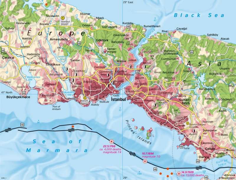
Geological structures and earthquakes
The geological conditions in the Istanbul area can be understood with the help of additional atlas maps. In the region, the older Rhodope massif interlocks with young mountains of the Alpine orogeny. A transform fault runs through the area, i.e. a fault zone with horizontal displacement where the Anatolian Plate moves westwards past the Eurasian Plate. The map shows the course of the fault lines through the Sea of Marmara, only a few kilometres from Istanbul.
Fault surfaces run perpendicular to the seabed in the direction of the Earth's interior. The plates rub against them, exerting pressure on each other and becoming interlocked. Thus, a uniform horizontal movement cannot develop in the area of the rigid earth's crust. Instead, tensions arise that are suddenly released in earthquakes.
There were strong earthquakes with great destruction in the Istanbul area in 1509, 1766 and 1894, for example. In some cases, there were also devastating flood waves. Very severe earthquakes have been recorded in the region in 1928, 1944 and 1970.
Against this background, the risk of a very strong earthquake in Istanbul is considered high (magnitude up to 7.4; probability of occurrence 30 percent within the next 30 years). There is seismic monitoring (see map), but no advance warning is possible for earthquake events. The risk of a strong earthquake in the near future is also supported by the fact that a westward migration of the herd of strong earthquakes from Anatolia can be observed and that there has not been a strong earthquake in the Istanbul area for more than 100 years.
Damage risks
Today, the city centre shows contrasts in a small space. Historical quarters with architectural monuments that give the impression of an oriental city stand next to modern office skyscrapers made of glass and concrete. Because of the danger of earthquakes, public buildings such as schools and hospitals are increasingly being built earthquake-proof. The safety requirements for new buildings have been raised to a level comparable to California and Japan. However, it is practically impossible to bring the standard of the numerous existing buildings up to this level.
This results in considerable risks in the event of a major earthquake, especially in the coastal districts with relatively old buildings between the old city and Atatürk Airport. At a magnitude of 5 to 6, serious damage to vulnerable buildings is to be expected. At a higher magnitude, large-scale damage is to be expected even to robust buildings.
Urban development
The map section essentially shows the urban area of Istanbul. At 5461 square kilometres, it is about one-third the size of Thuringia. Only the area in the southeast around Gebze belongs to the neighbouring province of Kocaeli. In addition to settlement areas, the city area also includes farmland and forests.
Istanbul's population is a good ten times that of Munich. It has grown strongly in recent decades. In 2000, Istanbul had around 9 million inhabitants, in 2008 around 12.6 million, in 2014 almost 14.4 million, 15,1 in 2020. The population increase is due to three factors: natural population growth, high immigration and the expansion of the urban area through incorporation. Growth rates are currently slowing down (2006: +2.5% on the previous year, 2014: +1.5%).
Population growth is reflected in the expansion of built-up areas (see map), which is often accompanied by the demolition of entire neighbourhoods, forced relocation or displacement of the resident population. Many immigrants are initially accommodated in unplanned settlements that are later legalised. Despite elaborate urban development and infrastructure projects, growth in the metropolitan region is uncontrolled in many places. According to estimates, around 85 percent of the newer buildings in Istanbul were constructed without permission.
