
Iceland - Physical map
Physical map
978-3-14-100890-6 | Page 76 | Ill. 1
Overview
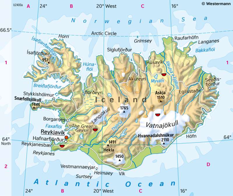
The island of Iceland is about 100,000 square kilometres in size, which is slightly smaller than the East German federal states combined or about three times the size of North Rhine-Westphalia. It sits on the Mid-Atlantic Ridge, whose central area crosses Iceland from southwest to northeast.
Volcanism, glaciation and settlement
The Earth's crust is particularly thin at this point, so Iceland has numerous active volcanoes. They form a chain that marks the course of the mid-ocean ridge. The geysers show a similar spatial distribution pattern. They are an indication of Iceland's high geothermal potential, which is used in geothermal power plants.
Iceland's northern location near the Arctic Circle is indicated not only by the grid, but also by the glaciation close to the sea. The Vatnajökull glacier has the shape of an ice cap and, with an area of 8100 square kilometres, is the second largest glacier in Europe. After increasing in size during the Little Ice Age (between the 15th and 19th centuries), it is currently shrinking.
Settlements and transport show a clear orientation towards the coasts. The most important city is Reykjavik. Around 36 percent of Iceland's population lives in the capital. The interior of the island, which has been permanently inhabited since the 9th century, is hardly developed.
