
Germany - Physical map
Physical map and the Rhine-Ruhr region
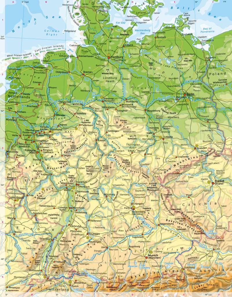
978-3-14-100890-6 | Page 94 | Ill. 1
Overview
Germany can be subdivided in large landscapes as follows (from north to south):
- the North German Plain, which were largely shaped glacially or periglacially during the last ice ages, including the coasts and offshore islands,
- the German Central Uplands (low mountain range) including the intercalated ditches or basins and the large scarplands (see 61.3),
- the Alpine foreland or foothills and
- the Alps as high mountains.
Neighbouring countries and major rivers
The map also shows Germany's neighbouring countries: Poland, the Czech Republic, Austria, Switzerland, France, Luxembourg, Belgium, the Netherlands and Denmark. Germany has the longest borders with Austria and the Czech Republic, the shortest with Denmark. The borders often run along rivers or mountain ridges.
In addition to the mainland, the 12-mile zone off the coasts of the North Sea and the Baltic Sea is also part of the national territory, but not the so-called exclusive economic zone in this area (200-mile zone).
Germany is divided by a main European watershed running southwest-northeast, mostly along mountain ranges. Large parts of Germany drain via the Rhine, the Ems, the Weser and the Elbe and a number of smaller tributaries to the North Sea or via the Trave, the Warnow, the Peene and especially the Oder to the Baltic Sea. Parts of southern Germany drain via the Danube to the Black Sea in south-eastern Europe. Only the Main-Danube Canal connects the river systems of these large areas.
Settlements and transport axes
In southern Germany and along the Rhine, there are some settlements with a very long history since Roman times (for example Regensburg, Trier, Cologne). However, towns and villages in Central Europe were founded mainly during the Middle Ages. Places with special characteristics were often chosen for this purpose, for example:
- Location close to natural harbours or rivers,
- location at crossroads of trade routes,
- topographically prominent points such as the transition from a valley to a plain or an island in a river,
- proximity to raw material deposits,
- proximity to castles or monasteries.
In many places, this is also reflected in today's settlement pattern.
Subsequent impulses for the founding and development of towns came from absolutist rulers (e.g. Karlsruhe), from industrialisation (e.g. Ruhr area) and from political caesuras such as the world wars, the division of Germany and reunification.
Particularly noticeable today are settlement concentrations such as the Ruhr area, the Rhine-Main area and the Rhine-Neckar area, some of which developed into largely closed settlement areas in the course of industrialisation, the four German cities with over a million inhabitants, Berlin, Hamburg, Cologne and Munich, as well as some twin cities (for example Wiesbaden and Mainz, Mannheim and Ludwigshafen, Fürth and Nuremberg).
The greatest diversity of transport modes, the most single locations (such as airports) and the greatest network density can be observed along the Rhine corridor, which is part of the densely populated economic core area of the EU. It forms the backbone of the German transport system. This is followed by main axes in the direction of Bremen - Hamburg, Hanover - Berlin and Stuttgart - Munich. In peripheral regions, transport is usually limited to a few locations and routes (for example in East Brandenburg and Western Pomerania).
