
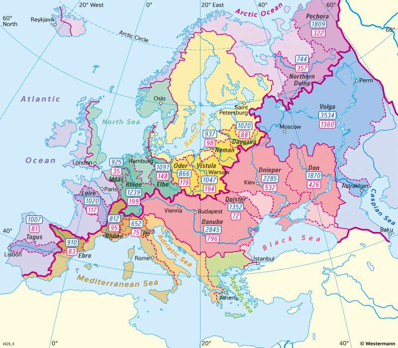
Europe - River basins
Topographic orientation
978-3-14-100890-6 | Page 48 | Ill. 1
Overview
The drainage basin is the area or surface of land from which a water system draws collected precipitation, i.e. the area within the watersheds of the water body. The drainage basin includes all the surface water from rain runoff, snowmelt, hail, sleet and nearby streams that run downslope towards the shared outlet, as well as the groundwater underneath the Earth's surface. The colour differentiation of the main catchment areas of the seas makes it possible to distinguish not only the main European watershed but also the other watersheds. The Main European watershed separates the drainage basins of rivers that drain to the north-east to the Atlantic (North Sea, Baltic Sea) from those that flow to the Mediterranean or Black Sea. The main watersheds of the lower category separate the drainage basins of the individual sea sub-areas from each other (e.g. Adriatic, Agais). Further watersheds distinguish the catchment areas of individual rivers from each other.
Europe's river systems
In the northeast, the Pechora and the Northern Dwina form the longest tributaries to the Arctic Ocean. An almost closed drainage basin from the Baltic to Sweden frames the Baltic Sea, which has a low salinity due to the freshwater inflows from the Oder, Vistula, Memel and Duna and the low exchange with the Atlantic. The North Sea is supplied by the longest tributaries, the Meuse, Rhine and Elbe, and other rivers from the British Isles, Scandinavia, and Jutland. The drainage basin of the Atlantic Ocean includes Portugal with the Tagus, the western parts of Spain and France with the Loire, the British Isles and Norway and Iceland. Draining southeast into the Mediterranean are the Ebro and Rhone, the longest tributaries of Spain and France, as well as the western part of Italy. The Po and the coastal areas supply the Adriatic Sea, while across the Pindos Mountains and the Peleponnes runs the dividing line to the Agais. The Black Sea has a huge drainage basin: the Danube, Dniester, Dnipro, and Don alone account for 1.8 million sq. km of surface area. In the southeast there is the Caspian Sea, which is fed by the Volga and other rivers. fed by the Volga, among others.
