
Europe - Population density and metropolitan areas
Population and migration
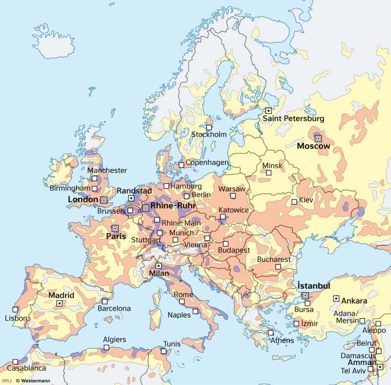
978-3-14-100890-6 | Page 68 | Ill. 2
Overview
Europa steht unter allen fünf Kontinenten hinsichtlich der Gesamtbevölkerungsdichte an dritter Stelle hinter Asien und Afrika.
Geographic-spatial distribution
The map shows the predominantly dense, yet uneven distribution of the population in Europe. In northern Russia and Scandinavia, in Iceland and in northern Scotland, the continent is very sparsely populated with less than one inhabitant per square kilometre. The decisive factor in these areas is the cold and altitude limit. Towards the poles, the altitude limit is much lower than in the Alps, where only the highest elevations have values of less than one inhabitant per square kilometre. Although here, as in other mountainous countries, there has been an economically induced migration of mountain farmers with the "altitude flight", the development of tourism has more than compensated for those departures.
Political and economic pull factors
That, despite these patterns, population distribution can by no means be attributed to natural factors alone is demonstrated by perhaps the most striking feature on the map, the density band of highest population concentration ("blue banana"). It runs from central England to central Italy and, although its boundaries are not clearly defined, was at times home to around 60 percent of the EU's inhabitants. The majority of European industry is located in this economically dynamic axis of Europe, which is by no means a closed entity, but rather is made up of several metropolitan areas. What is more important today, however, is that, with cities like Brussels, political decision-making centres and, with areas like London, Rhine-Main or Zurich, the centres of services - for example banks and stock exchanges - are also concentrated in this density band. The most populous agglomerations in Europe are listed in the bar chart on the left. It is clearly visible that the leading cities are Moscow
Distinctive areas of dense settlement
In many countries, the relatively dense settlement of the coastal areas is striking, for example in Italy, Spain, and Portugal, but also on the Black Sea and North Sea coasts. Denser bands of settlement are also found along some rivers, which, like the coasts, are often areas of agricultural and economic activity. The graph shows that the most populous agglomerations of Europe are Moscow and Istanbul by far, followed by other cities such as Paris or London.
Agriculturaal areas
Agricultural potential only plays an important role as a cause of population distribution in regions with low industrial density. Examples of this are Anatolia, the Taurus, and many areas in Russia, where the agricultural activity of the respective regions is reflected in the distribution pattern of the population.
