
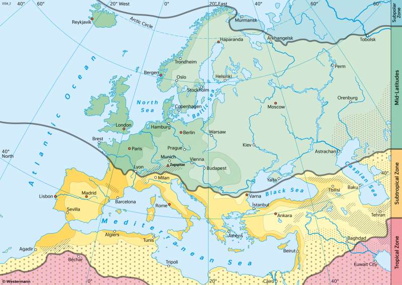
Europe - Climate zones (according to A. Siegmund and P. Frankenberg)
Climate
978-3-14-100890-6 | Page 53 | Ill. 5
Overview
Geographical regions with long-term similar or identical climatic conditions are understood to belong to a common climate zone. The starting points for the classification are the three climate elements temperature, precipitation and potential evapotranspiration. In this way, different climate zones can be distinguished from north to south and from west to east in a global context.The following climate zone model corresponds to the climate classification by A. Siegmund and P. Frankenberg.
First climate key: Thermal climate zones
The division of the Earth into five thermally defined climate zones forms the basis of the climate classification. The example of Europe shows a largely zonal arrangement. Especially over large land masses, however, the climate zones often do not run parallel to the latitude circle. Over western and northern Europe, for example, the Mid-Latitudes bulge northwards, caused by the Gulf Stream, a warm ocean current that reaches as far as areas north of the Arctic Circle.
Third climate key: Heat balance / continentality
The third level of the Siegmund/Frankenberg classification approach is thermal continentality. This statistical measure is based on the annual amplitude of the monthly average temperatures. With its help, four degrees of continentality or maritimeity can be distinguished, which are abbreviated with numbers: high maritime, maritime, continental, and high continental. They are used outside the tropics (where the annual amplitude would be uniformly low and therefore not meaningful) and are represented as colour grades of the thermal climate zones.
Second climate key: Dry climates
At the level of this climate key, the arid or semi-arid dry climates are additionally summarised. The 250-millimetre isohyet of the annual precipitation is used for delimitation. If the precipitation of a location falls below the potential evapotranspiration (N < pLV), the climate is defined as arid, in the opposite case (N > pLV) as humid. In semi-arid climates, some months during the course of the year are humid (for example, due to subtropical winter rains), the vast majority of months are arid..
Combination of climate keys
The combination of the levels described above results in a tripartite climate key. Large parts of Central Europe, for example, lie in a maritime climate of the Mid-Latitudes. Egypt lies in the arid tropics or subtropics. In the Mediterranean region, there is a contrast between maritime-influenced, warm areas characterised by subtropical winter rains in the north or upwind of large mountain ranges and subtropical dry climates, which characterise large parts of Libya and Egypt.
In order to assess the climatic conditions of a location, it makes sense to assign corresponding climate diagrams to specific climate zones and climate types. Such a classification can be made on the basis of the marked stations.
