
California and Nevada - Precipitation and surface water management
Land use and water management
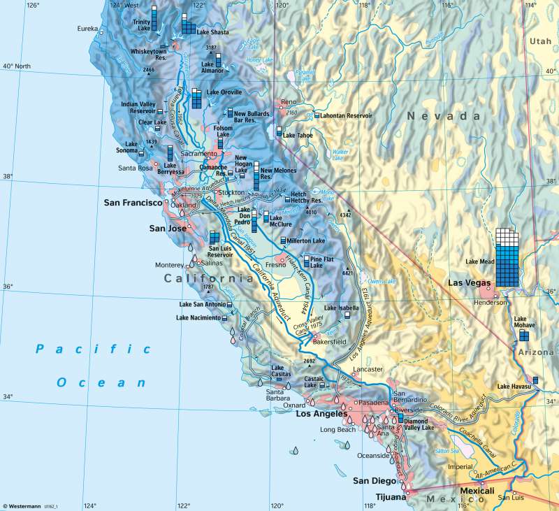
978-3-14-100890-6 | Page 187 | Ill. 4
Overview
For many years, California has been the undisputed leader among the US states in terms of agricultural value, and the coastal state also has the highest population of the US states due to sustained population growth. The sprawling urban agglomerations in San Francisco and Los Angeles, but especially agriculture, require a lot of water. California only became a strong attraction for settlers, farmers, and businesses in the 20th century through extensive irrigation projects, which today form the basis for intensive agricultural cultivation. Especially in the southern areas, where less than 250 millimetres of precipitation fall, crop cultivation is not possible without irrigation. Due to the diversity of agricultural land use in California, technical measures in water management are required.
Water use and irrigation projects
The water supply in the state of California consists of groundwater, surface water (rainfall and snowfall in the mountains between October and May) and water from desalination plants. About 75 percent of the surface water available in California comes from the region north of Sacramento, where precipitation is relatively high, and evaporation is comparatively low. However, about 80 percent of the demand is concentrated in the area south of Sacramento, where precipitation is much lower and evaporation is incomparably higher (see climate graphs on page 187). This creates considerable water deficits. In addition, the Los Angeles agglomeration area is located to the south. In addition to this spatial inequality in the distribution of water resources, there is also a temporal discrepancy between water supply and demand. The water supply of the rivers reaches its minimum between August and November. Therefore, in late summer only a very small amount of water is available, while the demand for irrigation water is particularly high during this period. The pictures in 187.3 show the variability of water in rivers in California after the rainy season and at the end of the dry summer with high water usage. Although a variation of precipitation during the wet season throughout the years is common, the mean amount of precipitation now slowly decreases, leading to less water available for use, especially in agriculture.
Households, industry and commerce but especially agriculture consume a great amount of water. To ensure the water supply, large facilities were built to store, transport, and distribute the water. For agriculture, the Central Valley Project (CVP) and the California State Water Project (SWP) were the most significant measures. The Central Valley Project dates back to plans submitted as early as 1873 but were only realised between 1938 and 1951. The water that accumulates in the winter months in the northern part of California is collected and stored in large reservoirs - above all the Shasta Reservoir. The map shows the reservoirs in the area as well as their water holding capacities. Canals with a total length of more than 560 kilometres transport the water to the areas of demand. The most important reservoir of the State Water Project, which was started in the 1950s, is the Oroville Reservoir. The most important canal is the 700-kilometre-long California Aqueduct, which supplies the farming areas in southern California (near San José and in parts of the San Joaquin Valley). The California Aqueduct connects 20 reservoirs and dams, five power plants, 17 large pumping stations and about 200 kilometres of lateral canals. The urban areas are partly supplied by additional systems. For example, the Los Angeles area also draws water from the Owens Valley, located east of the southern Sierra Nevada.
