
Asia - Precipitation and winds in July
Agriculture and climate
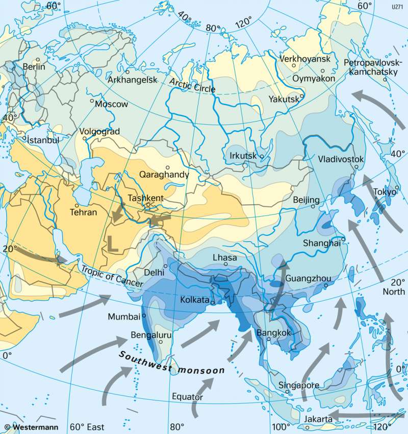
978-3-14-100890-6 | Page 121 | Ill. 5
Overview
The rainfall distribution over Asia shows a sloping trend from the humid tropics to the interior of the continent. In many parts of Southeast Asia and India there can be between 1000 and 3000 mm annual rainfall, the highest amount in Asia. In Central Asia, the rainfall passes through the increasing hygric continentality and the lee of the Himalayas and back to partially less than 100 millimetres (Gobi Desert). In the Arab region the influence of the descending air of the subtropical high-pressure belt is strongly felt, and also results in annual rainfall amounts of 100 mm and below there.
The rainfall regime in Asia
The rainfall regime in Asia is determined by the major circulation elements of the atmosphere. In some areas north of the 40th Latitude, westerly winds are dominating. The "wandering cyclones " of the west wind drift, lose a lot of water vapour on their way from the coast of Europe into the interior of Asia and sometimes they dissolve completely. And so, the annual mean of the continent east of the Urals is relatively dry. The rainfall here is mainly a result of convective clouds which strongly heat the land masses in the summer. The term hygric continentality is a summer rainfall maximum.
South of the Tibetan Plateau and in East Asia, the westerly wind entropical regime is intertwined with the onshore trade wind regime. Those in the zenith position of the Sun, shift in atmospheric circulation belts and lead to summer rainfall within the distribution area of this "East Asian monsoon".
In the equatorial regions of Malaysia, Indonesia and parts of the Philippines, the continuing influence of the Intertropical Convergence Zone (ITCZ) dominates with its year-round rainfall in the equatorial westerly wind regime.
In India and in large parts of Southeast Asia, the precipitation regime is essentially shaped by the seasonal alternation between dry northeast winds from the interior of Asia in winter and the humid air masses of the southwest monsoon in summer. During the winter monsoon, a ground-level air current from the continent blows from the north onto the Indian Ocean. Above this, westerly wind currents that have shifted to the south dominate, which are split into a northern and a southern branch by the Tibetan Plateau. They converge again in the lee of the highlands (Tibetan convergence zone). A shallow thermal high pressure area forms above the cold Tibetan Plateau. This cold source causes a large temperature contrast to the south, which drives and anchors the southern branch of the ectropical westerly wind jet. Descending movements under this jet stream cause northerly dry winds to flow out near the ground. Thus, drought prevails in large parts of India in winter, only in northern India and Pakista isolated low-pressure areas in the westerly flow do lead to ectropical winter rains.
From March onwards, the weather in northern India becomes hot and dry due to the higher solar radiation. In this pre-monsoon phase, the first low-pressure disturbances with higher precipitation occur in the Ganges delta due to the overlapping of cold air at altitude and warm air masses on the ground. This marks the beginning of the summer monsoon in Bengal, Bangladesh, Assam and Buam, which only reaches India a few weeks later with a powerful south-westerly current and China with a more southerly current. The monsoon rains begin around the end of May in southwest India and reach their northernmost position in the north of the subcontinent around 15 July.
Over India, monsoon precipitation falls not only from the southwest monsoon current, but also from monsoon depressions that develop over the warm Bay of Bengal. In summer, high-altitude troughs of the westerly wind drift above the Tropical Easterly Jet stimulate the formation of such low-pressure vortices twice a month on average. The monsoon depressions are integrated into the tropical easterly current and thus move west or northwest from the Bay of Bengal against the southwest monsoon. They bring extremely high rainfall, especially to eastern India and Bangladesh. In contrast, the hinterland in southern and western India (Deccan Plateau), which is located between the migration paths of monsoon depressions and the southwest monsoon, has little precipitation all year round.
