
The World - Precipitation in January (northern winter / southern summer)
Climate elements
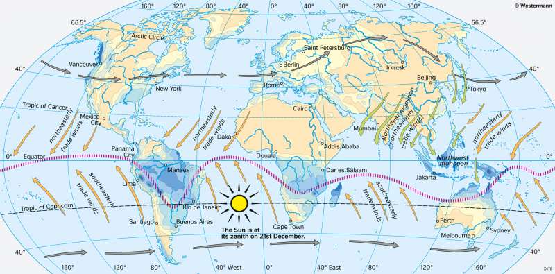
978-3-14-100890-6 | Page 18 | Ill. 3
Overview
The two climate maps illustrate the large regional and seasonal differences in precipitation distribution on earth. The close connection between the illumination of the Earth, the shift of the inner-tropical convergence zone in the course of the year and the amount of monthly precipitation becomes clear.
The shift of the ITC and ist influence on precipitation
In the beginning of spring in March, the Sun is at its zenith at the equator, whereas during the northern summer/southern winter (July) it is close to the Tropic of Cancer. The zenith of the Sun has therefore moved northwards, and the Northern Hemisphere receives more sunlight than the Southern Hemisphere. The zone of maximum tropical precipitation follows the moving zenith of the Sun. At this time, it is clearly north of the equator over the continents and even extends beyond the Tropic of Capricorn in Southern Asia. Above the continents, the position of the tropical-subtropical dry areas shifts far to the north.
It the beginning of autumn in September, the Sun is again at its zenith at the equator, whereas during the northern winter/southern summer (January) it is close to the Tropic of Capricorn. The zenith of the Sun has therefore moved southwards. The Southern Hemisphere now receives more sunlight than the Northern Hemisphere. The moving zenith of the Sun is followed by the zone of maximum tropical precipitation. At this time, it is clearly south of the equator over the continents and in South America even extends beyond the Tropic of Capricorn. Above the continents, the position of the tropical-subtropical dry areas polewards shifts far to the south.
When comparing the position of the inner-tropical convergence zone in January and July, it is noticeable that it moves further polewards above the continents than above the oceans in summer - a consequence of the faster and stronger warming of continental masses compared to marine surfaces and the associated intensification of tropical convection.
The seasonal shift of the inner-tropical convergence zone is accompanied by a corresponding shift of the other pressure and wind belts. For example, its extreme northward shift in July over the Indian subcontinent results in a deflection of the original southeast trade wind of the Southern Hemisphere as it crosses the equator (monsoon). In the Mediterranean region, the influence of the westerly wind circulation and subtropical high-pressure areas alternate in the course of a year.
Wind systems
Due to the spherical shape of the Earth, the various latitudinal zones of the Earth receive different amounts of energy from the Sun (see diagrams on day length 18.1 and 19.2). As the angle of the Sun's rays at the Earth's surface decreases from the equator to the poles, the energy supply decreases more and more. The intense solar radiation in the tropics and subtropics leads to an energy surplus compared to higher latitudes. The atmosphere tries to balance out these energy contrasts between equatorial and polar latitudes. This results in the Earth's large, very consistently blowing wind systems.
Trade winds are very constant winds that blow all year round and work because of descending air movements in the area of the tropics. They occur widely in the tropics, in the Northern Hemisphere as northeast trade winds and in the Southern Hemisphere as southeast trade winds. Both currents converge over the large oceans all year round in the Intertropical Convergence Zone (ITCZ). This belt, only a few hundred kilometres wide, is the zone of heaviest tropical precipitation. Its cause is the rise of warm, humid air. This causes high clouds to form, from which heavy rain falls several times a day.
The strongest tropical precipitation also falls above the continents in the ITCZ area. Seasonally, however, the ITC shifts more to the north and south and not above the oceans. Above the continents, trade winds are particularly dry, such as in North Africa or in the northern winter half-year over India ("northeast monsoon"). When a trade wind crosses the equator, its direction of movement changes. This way, the southeast trade wind above the Indian Ocean is redirected to a monsoon in the area of the Arabian Sea during the northern summer. As it sweeps over large areas of sea during this time, it picks up large amounts of moisture that lead to high precipitation when it passes over the land ("southwest monsoon"). This is in stark contrast to the opposite northeast monsoon.
Between the tropics and the polar regions on both hemispheres of the Earth lies a westerly wind zone, in whose area westward-moving low-pressure areas determine the weather pattern. They are not only the main rains in these regions, but also ensure a balance of warm tropical-subtropical and cold polar air masses. For example, a low-pressure area above the North Atlantic directs warm tropical air northwards on its eastern side and cold polar air southwards on its back side in the west. This way, typical warm and cold fronts are formed, which are coupled to a westerly flow at the height of the atmosphere and therefore move westwards from the Atlantic into the continent. In the area of the advancing warm front, the air masses slide onto the cooler and thus heavier air stored near the ground. Extensive stratus clouds form, from which persistent precipitation can fall (land rain). On the cold front, polar air masses push forward against the warm and thus lighter tropical air. Cumulus clouds form, from which shower-like precipitation falls.
The comparison of the wind systems in January and July clearly shows the seasonal shift of the overall system, which follows the zenith position of the Sun with a certain delay.
