
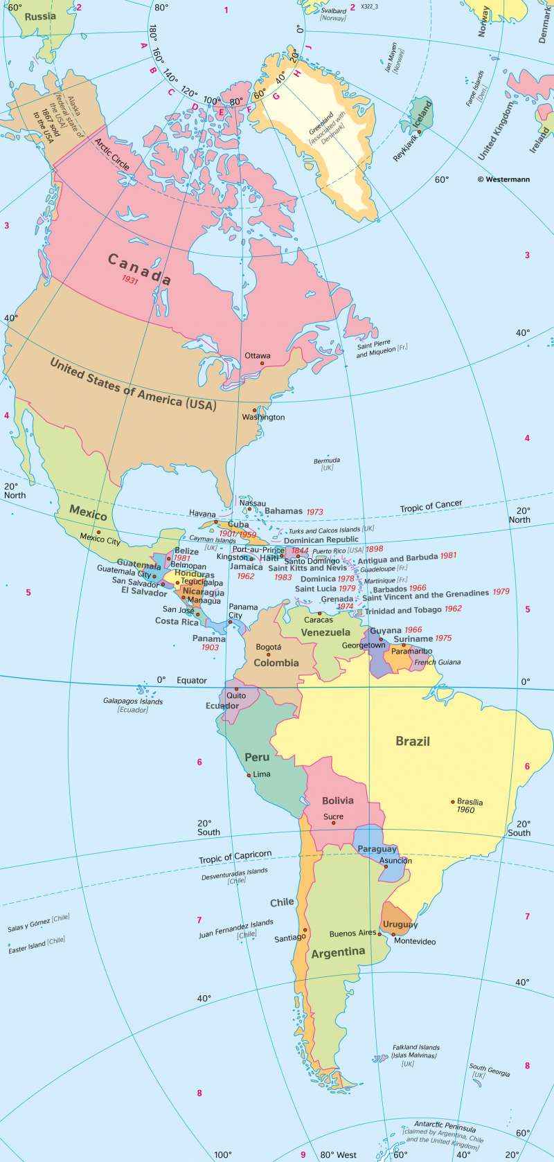
The Americas - Political map
Immigration shaping the political landscape
978-3-14-100890-6 | Page 170 | Ill. 2
Overview
The political map shows the 35 countries in the Americas and names their years of independence. It also identifies the capitals of the American countries.
A look at some countries in America
Greenland, in Danish possession since the early 18th century and recognised as an equal part of the Kingdom since 1953, received a new self-governing statute in 1979 following a referendum. Since then, Denmark has regulated the island's foreign, defence, and monetary policy, while economic, social, and cultural policy are among the tasks of the Greenlandic government. More than three quarters of the 56,000 inhabitants (2020) are Inuit.
Canada became independent after a history of autonomy aspirations and regional mergers through the Statute of Westminster in 1931, with Newfoundland joining as the tenth province in 1949. In the formerly French and still predominantly French-speaking province of Québec, there were repeated separatist efforts in the second half of the 20th century.
In 1849, the Oregon Territory in the western USA comprised the present-day states of Oregon, Washington, Idaho, and parts of Montana. Oregon was admitted to the Union in 1859, followed by Washington, Montana (both in 1889) and Idaho (1890). The last states to join the Union, giving the USA its present form, were Oklahoma (1907), Arizona and New Mexico (1912) and Hawaii and Alaska (1959).
In Central America, the borders that emerged during the nation-building phase in the early 19th century are still in place. More recent are the states of Panama, which gained independence from Colombia in 1903, and Belize, the former British Honduras, which was granted limited autonomy in 1964 and has been independent since 1981. Although there is a head of government, Queen Elizabeth II is still head of state. She is represented by a governor. The islands of the Caribbean gained their independence mainly in the second half of the 20th century.
In South America, some of the borders have shifted slightly since 1825, without decisively changing the division of the nation-state. Today, Guyana is divided into Guyana (1966, formerly British), Suriname (1975, previously Dutch), and the former penal colony of French Guiana. The Chaco War in the 1930s changed the course of the border between Bolivia and Paraguay. Peru had to cede some parts of the country to Chile in the south but was able to expand in the north at the expense of Ecuador in 1942. The Falkland Islands in the extreme south were the trigger for a war with Great Britain in 1982 after their occupation by Argentina, which ended with a victory for the British troops.
