
The Americas - Physical map
Topographic orientation
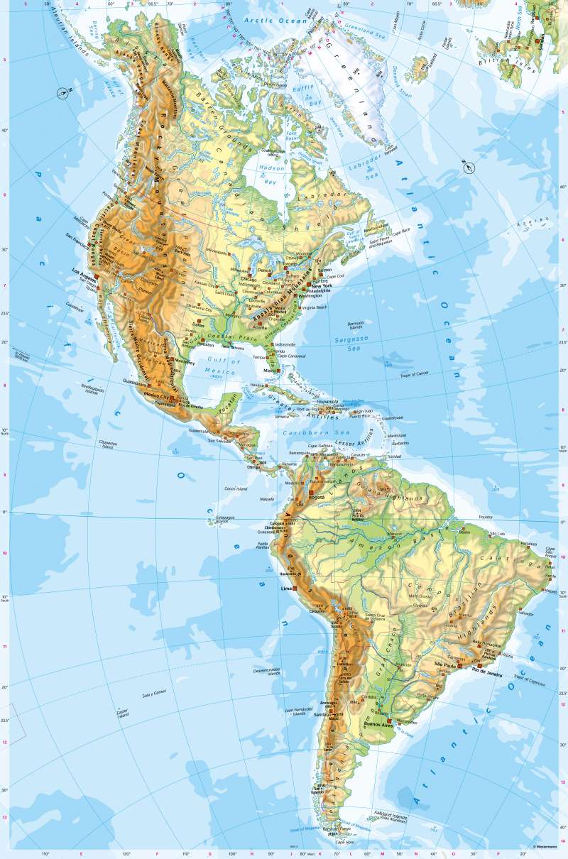
978-3-14-100890-6 | Page 168 | Ill. 1
Overview
Considered as a unit, the Americas are the largest continent on earth and about four times the size of Europe. South America on its own is the fourth largest continent, North America the third largest. In terms of population, the whole of the Americas ranks second (after Asia), with North America and South America ranking fourth and fifth respectively behind Europe.
Major geographical units of the Americas
North and South America are two vast land masses that share great similarities in geological construction and are connected by Central America as a land bridge. Compared to the other continents, the large north-south extension is striking, reaching from the areas north of the 70th latitude to Tierra del Fuego south of the 50th latitude. North and South America thus share all geographical zones. The high mountain belt in the west is particularly striking. It has a great influence on climatic conditions because it acts like a bar. Evidence of its still geologically young age are the tectonic activities: Active volcanoes and a high earthquake risk characterise the mountain belt.
North America can be divided into four major landscapes. The geologically young, folded mountain belt in the west with its north-south orientation continues to South America and reaches its greatest width in the area of the Great Basin. To the east of this lie wide, open landscapes (Great Plains), which either contain large lakes or are traversed by the Mississippi River and its tributaries. There, the waters form distinctive lines (chain of lakes from Bear Lake to Lake Erie, Hudson Bay, St. Lawrence River, Mississippi River). In the west of North America lie the Appalachian Mountains. Coastal plains there mark the transition to the Atlantic Ocean. The archipelagos in the Arctic Ocean and Greenland form a large landscape in their own right.
With the very high, geologically young Cordilleras in the west, the extensive plains with their huge river systems in the interior and the lower, geologically old mountains in the east (Amazonian Shield, Guyana Shield), South America's geological structure and surface shape are very similar to North America. However, climate and vegetation are completely different in many places due to their location in the tropics. Despite their altitude, the Andes are the oldest settlement area, and their preference has not changed to this day (see Colombia). Settlement is otherwise coast-oriented in most states.
Central America forms a narrow, mountainous land bridge connecting North and South America. Offshore to the east are the Greater and Lesser Antilles, separated from the mainland by the Gulf of Mexico and the Caribbean Sea, respectively.
In the large agglomerations, individual cities have grown together to form extensive urban landscapes. They are among the largest and most populous on earth.
