
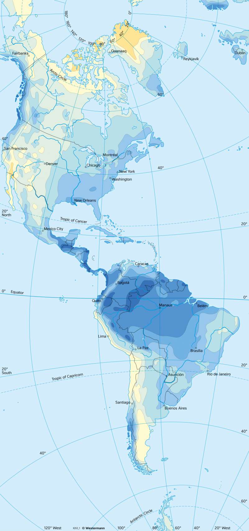
The Americas - Annual precipitation
Climate
978-3-14-100890-6 | Page 173 | Ill. 3
Overview
The determining influence of the mountain ranges parallel to the coast is clearly evident in the distribution of precipitation.
Rainfall patterns in the Americas
Along the Rocky Mountains and the Andes, the westerly winds that prevail all year round beyond the 35th degree of latitude accumulate and result in corresponding upslope rainfall. As a result, a narrow coastal strip upwind of the Cordillera receives average annual precipitation of up to 3000 millimetres. In the lee of the coastal mountains, precipitation decreases rapidly due to foehn-like descending air masses. In North America, these warm downdrafts are called chinook. In this way, precipitation on the eastern side of the Rocky Mountains and the Andes in the westerly wind zone sometimes reaches less than 250 millimetres per year.
In the southwest of North America and along the South American west coast between 5° and 35° south latitude, the influence of the subtropical high pressure belts is also noticeable. The North and South Pacific Highs cause a very strong decrease in precipitation due to the divergence of the air masses near the ground and the associated cloud dissipation. Cold upwelling waters from the California Current and the Humboldt Current intensify the sinking of the air masses and the associated drought. With partly less than 100 millimetres in the long-term precipitation average, desert-like conditions prevail, such as in the Mojave Desert and the Atacama Desert.
The precipitation map shows higher precipitation amounts in the south and east of North America near the coast than inland. The precipitation results from humid air masses over the warm sea surfaces of the Caribbean, which are rained down along the coasts by onshore winds, causing annual precipitation amounts of up to 2000 millimetres in some places. Due to the much lower altitude of the eastern coastal mountains (Appalachians) compared to the Rocky Mountains, precipitation on the eastern side of North America can penetrate much further inland. This is why annual precipitation amounts of between 500 and 1500 millimetres occur there on a widespread basis.
Central America and equatorial South America are subject to the tropical circulation pattern of the Hadley cell. The seasonally shifting zenith of the Sun causes the formation of a shallow low over South America, which leads to a confluence (convergence) of the trade winds from the north and south. This area marks the location of the Intertropical Convergence Zone (ITCZ). The associated equatorial westerly winds lead to fairly consistent precipitation. For Central America and the Caribbean, the onshore northeast trade winds in particular bring precipitation. The east coasts receive more rain than the west coasts.
