
The Americas - Temperatures in July
Climate
978-3-14-100890-6 | Page 172 | Ill. 2
Overview
In the Americas, average temperatures in January range from less than -35 °C in northern Canada to more than 25 °C in large parts of the Amazon lowlands. In July, during the southern winter, on the other hand, temperatures are not as low as in the North American winter due to the stronger influence of the oceans in South America. They reach about 0 to -5 °C at high altitudes in the Andes, while the highest temperatures in the Caribbean region are over 30 °C.
Impact of wind systems
In terms of circulation dynamics, North America is predominantly subject to the regime of prevailing westerly winds in the area of the polar front at high altitudes. The westerly winds near the ground are particularly intense between the Aleutian Low and the North Pacific High. The high-altitude flow of the westerly wind jet is deflected by the Rocky Mountains in such a way that it undergoes a northward bulge (ridge) above them and a large-scale southward bulge (trough) in the lee of the mountains in order to swing northwards again towards the Atlantic.
The ridge over the Cordillera leads to the advance of warm air to the north, while the trough over the interior of North America supports the advance of polar and arctic cold air to the south. The low-pressure vortices (cyclones) with their typical warm and cold fronts that develop under the front of the trough suck in tropical warm air from the Gulf of Mexico. This causes the July isotherms over the eastern USA (west of the Appalachians) to spread northwards.
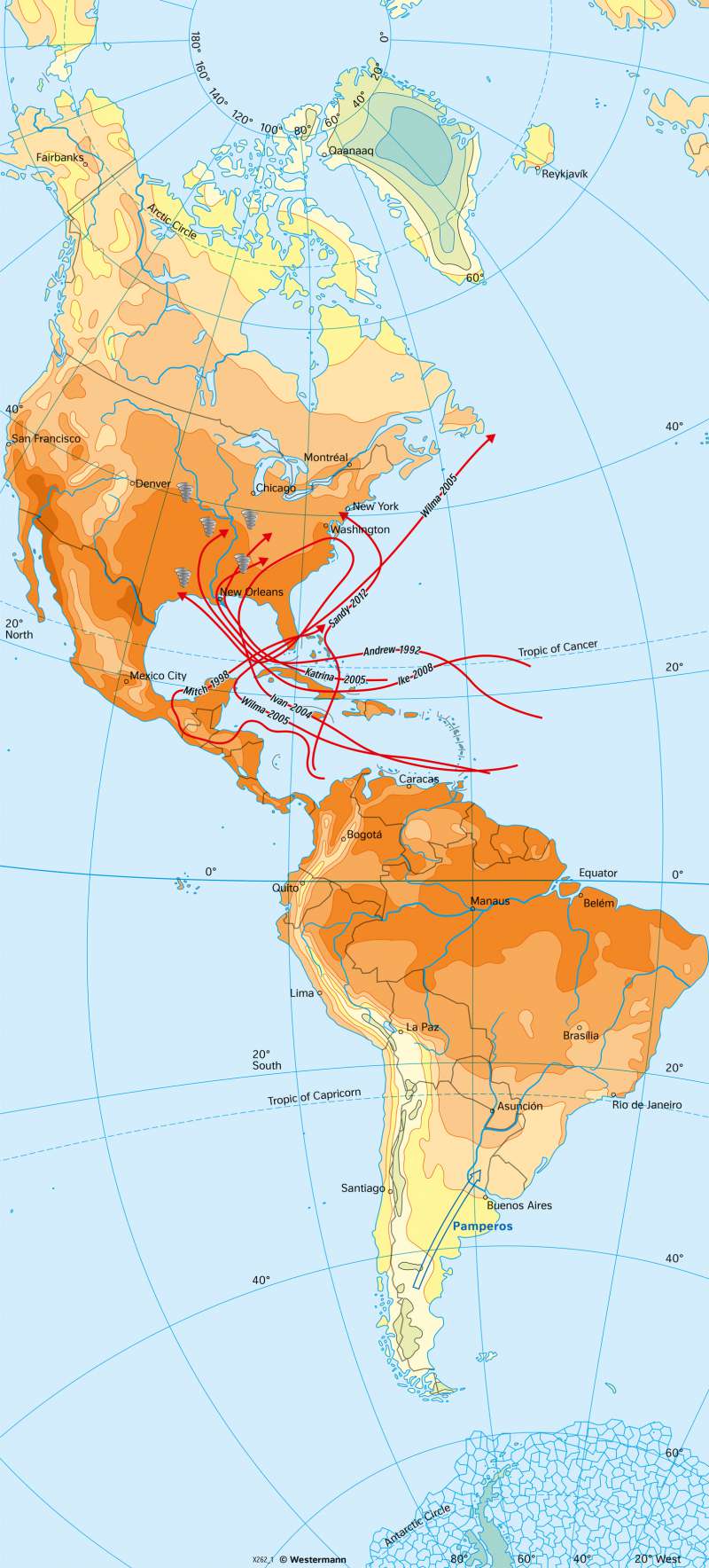
Due to the location and shape of the continent, but especially due to the north-south extension of the mountain ranges along the west coast, the weather in both North and South America is characterised by a strong meridional exchange of polar and tropical air masses throughout the year. This direct meridional exchange of warm, humid air masses from near the equator and cold air masses from the polar regions sometimes leads to extreme weather phenomena and the formation of characteristic regional wind systems. For example, blizzards and Northers in North America result in cold air influxes from the north in winter, which are often associated with high wind speeds and snowfall. The blizzards often reach the subtropical crops of Florida, and the sphere of influence of the Northers even reaches as far as central Mexico.
In South America, such cold air influxes from the polar regions also occur. There they are called pamperos.
Temperatures
In July, the isotherms over North America expand far to the north due to the faster warming of the land masses in the interior of the continent and the repeated advance of tropical air masses. The 25 °C isotherm extends to the 50th latitude. The strong labialisation associated with the warm, humid air masses from the south favours the formation of tornadoes in summer. They occur most frequently in spring and early summer, when the thermal and hygric contrasts between dry-cold air from the north and warm-humid air from the Gulf of Mexico are at a maximum. The core area of tornado danger is initially in the area of the Gulf Coast states in March, from where it then expands into the continental interior of North America by midsummer. The air column of a tornado rotating around a vertical axis can reach a diameter of more than one kilometre, the direction of migration always follows the altitude current from southwest to northeast.
In summer and autumn, tropical cyclones can also form in the moist, warm and unstable air masses of the Caribbean region at water temperatures of 26 to 27 °C. These are known as hurricanes in North America (cf. map 173.5). In the overriding tropical easterly current, they move across the Caribbean islands to the American continent, where they wreak havoc when they hit land.
Characteristic of South America is the transition from tropical diurnal climates to extratropical seasonal climates. While the average temperatures in the areas near the equator differ only slightly in January and July, there are sometimes considerable temperature amplitudes during the course of the day. With increasing latitude, the seasonal temperature differences increase. This is evident beyond the tropics in both South and North America.
Much more striking than the meridional temperature differences is the thermal zonation of altitude, especially in South America. The levels of the frost-free lowland tropics there are called tierra caliente (average annual temperature of over 22 °C) and tierra templada (16 to 22 °C). Around the equator, this altitude level of complete frost-freeness reaches about 2500 metres and drops down towards the poles. With increasing altitude, these warm tropics change into cold tropics. With average temperatures of 6 to 16 °C, frosts already occur regularly in the area of the Tierra fria. At an altitude of about 3500 metres in the equatorial Andes, the zone of the tierra helada is reached with an average of 0 to 6 °C. The number of frost-changing and icy days increases sharply. The tierra nevada marks the area of perpetual snow and begins in the humid inner tropics at about 5000 metres.
