
Golfito (Costa Rica) - Rainforest restoration
Vegetation, agriculture and conservation
978-3-14-100890-6 | Page 175 | Ill. 3
Overview
The atlas shows two thematic maps of the rainforest in Costa Rica on this double page. Both focus on the Piedras Blancas National Park. On the one hand, this nature reserve is dedicated to species protection and biodiversity; on the other hand, a special focus is placed here on the restoration and enhancement of large contiguous rainforest areas.
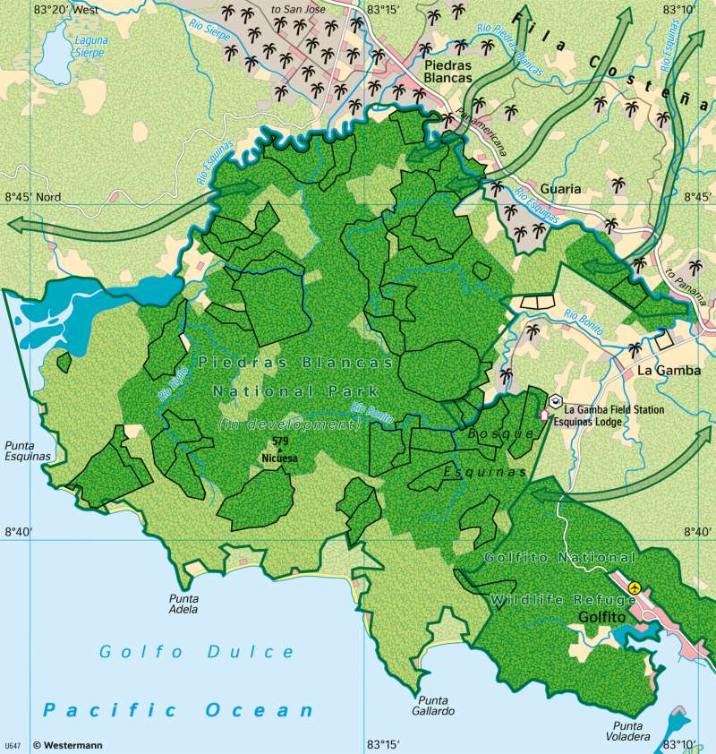
Rainforest restoration near Golfito, Costa Rica
This map (175.3) shows the 140 km² Piedras Blancas National Park, which was established by law in 1991 and is located on the Pacific Coast in southern Costa Rica, near the town of Golfito. It is a special forest reserve with the aim to connect (and ecologically enhance) the still existing patches of primary tropical rainforest through land acquisitions and forestry measures. Many of the local lands have been privately owned and were used decades ago by - rather extensive - grazing.
For more than 30 years, the European association ‘Rainforest of the Austrians’ has been buying land from local landowners in order to convert it back into rainforest areas in the long term. The purchased land is handed over to the state national park programme. In this way, more than 40 km² have already been incorporated into the national park. However, there are still parcels of privately owned forest land (the light green areas) within the defined national park boundaries, that are to be further renatured in the long term.
In the project area, cleared areas are reforested with suitable tree species; biologists and rangers ensure the reintroduction and protection of endangered animal species. The land purchases and tree plantations are financed by donations from Austria, Costa Rica and other countries; scientific project monitoring and biological research are carried out by the University of Vienna, which maintains the biological research station La Gamba on the north-eastern edge of this rainforest area (see map 174.2).
In recent years, there have been increasing attempts to connect the ecologically valuable (but in part quite small) national parks in Costa Rica with each other through biological corridors. The idea behind is to create protected landscape areas in which not every kind of economic use is permitted, so that animals and plants are able to migrate or disperse more widely. The Piedras Blancas National Park with its limited area will be linked with the hinterland in this way. Especially towards the nearby coastal mountain range Fila Costeña, whose ridge has remained close to nature, connections are to be established. For animals and plants, it is also an advantage that the naturally vegetated "Golfito National Wildlife Refuge" adjoins to the east.
Ecotourism at the Esquinas Lodge
The corresponding map 174.2 shows the Esquinas Lodge with its offers for nature-friendly rainforest tourism; it is located on the edge of the Piedras Blancas National Park in Costa Rica. This forest reserve on the southern Pacific coast of Costa Rica can be seen in its entirety on atlas map 175.3: Golfito (Costa Rica) - Rain forest restoration. The stream Rio Bonito leaves the national park at this location in a short, steep V-shaped valley, forming several small waterfalls.
In the Esquinas Rainforest Lodge there are 10 bungalows, in which 18 house halves are rented to tourists. Due to its location close to the undisturbed tropical rainforest, the lodge is particularly suitable for bird watching and getting to know the rainforest vegetation. Several narrow hiking trails lead up the valley slopes from the lodge and offer the opportunity to explore the wilderness. Guided night walks are also offered, revealing different wildlife than during the day.
Costa Rica's forests are known for their biodiversity, both in flora and fauna. The rainforest restoration in the Piedras Blancas National Park aims not only to secure this biodiversity, but also hopes to expand it (see map 175.3).
The scientists, employees and volunteers of this forest restoration project work in the biological field station La Gamba 500 metres downstream, which can also be seen on the map. From here they set out on their missions in the rainforest, partly also via the hiking trails shown. The closed rainforest extends beyond the national park boundaries to the Biological Field Station. Towards the east, farmland, pastures and plantations extend.
