
Bangladesh — Physical map
Eurasia - Physical
978-3-14-100790-9 | Page 91 | Ill. 2
Information
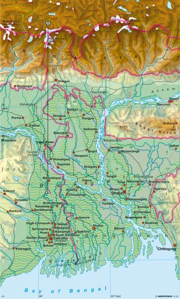
The densely populated Bangladesh is part of the Indian subcontinent and is surrounded almost entirely by India. The national territory consists largely of flood risk areas in the estuaries of the Ganges (Padma) and Brahmaputra (Jamuna) which amasses a widespread delta. The linings of the rivers are constantly changing, located just a few metres above sea level and causes an amphibious landscape appearance. In the flood zone of the rich, alluvial shallow water coast, "tidal forests" grow into mangroves in the sea. This forest provides the local population with burning material.Every year during the monsoon season, heavy rainfall and snowmelt in the Himalayas cause flooding of settlements and agricultural areas. If tropical cyclones hit the coast on the Bay of Bengal it is often with devastating floods and metre-high tidal waves. Even large cities such as Calcutta (11.5 million inhabitants), Dhaka (9.5 million inhabitants) and Chittagong (3 million inhabitants) are affected by these floods. The wettest areas are located at Silhat (Sylhet), in the Chittagong Hills and on the slopes of the Khasi Hills. Cherrapunji, with more than 11,000 mm mean annual precipitation, it is the wettest place on Earth. The reason for the heavy rainfall in these mountain areas is the accumulating effect of the ridges.
Floods and man-induced causes
The annual floods, peaking in August (summer monsoon) flood nearly half of the country. At maximum flood levels, discharge volumes cause unusually large waves to occur. In August, the flow of the Brahmaputra River is already at an average of about 44,000 m³ / s. On the other hand, the coastal and delta areas in the south are more vulnerable to storm surges of the sea, caused by tropical cyclones. As a result, the backlog of the current in the Delta water causes significant flooding far inland.
The floods are compounded by the logging of mangrove forests and in the Khasi Hills. The expansion of agricultural land by "slash and burn" agriculture leads to deforestation of entire mountainsides. The rains in the summer months, rinse the floor which then gradually seeps in to the ground and the protective canopy reduces the impact. The moisture stored in the soil is released in drier months. Nowadays, the deposited rinsed floor forms sediment in the river tributaries of the delta. The sludge load increases in the riverbeds and banks. Therefore, dams are only used sparingly with the large discharge volumes, resulting in huge floods. Following the flood disasters in 1987 and 1988, the government and the World Bank jointly developed a flood action plan (FAP by which risk areas should be protected from flooding by 2015). However, as different types of floods occur and some regions are affected to different degrees, it stirs resistance in the population.
Despite all these difficulties, the early actions of the government have already had positive effects. In the aftermath of severe tropical cyclone Sidr, which swept through Bangladesh in November 2007 and where over 750,000 homes were damaged, fewer than 2,500 people were killed. This was mainly due to the new early warning system, which was estimated by the United Nations to have saved countless lives.
D. Sayak, E. Astor; Ü: C. Fleming
