
Paris
London and Paris - Global cities
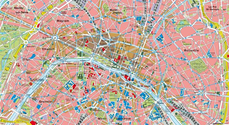
978-3-14-100790-9 | Page 69 | Ill. 6
Information
The map shows the core area of Paris, both elements of the historic urban development and the current functional structure can be easily seen. A prominent structural line is the Seine, which was crucial for the earliest development of the city. The starting point of the first settlement was a passage across the river in the area of (Ile de la Citié) which the Celtic tribe of the (Parisi) was located in a pre-Christian settement.Paris-Inner City
The streets of Paris have a certain geometric regularity to them which dates back to the Gallo-Roman city structure. The main roadways, parks and other infrastructure features are mostly the result of modern development. The location of Paris also plays a special role as a seat of royalty/power. The most striking elements of east-west axis were conceived by Louis XIV, a connecting straight line leads from the Louvre to the royal hunting forest of Saint-Germain-en-Laye. However, the main part of the boulevards only emerged around the middle of the 19th Century under the city prefect Baron Haussmann.
Under Haussmann, the great north-south central line between the east train station (Gare de l'est) and Montparnasse was built. It runs parallel to the two streets of Rue St. Denis and Rue St. Martin / Rue St. Jacques, which had already existed at the time. The large number of terminus stations is noticeable and they have been an important mode of transport for the suburban population since their installation in the 19th Century.
Among the special features of Paris is the clear practical differentiation of the inner city which is explained here by the historical development. It was supposed to partially reflect in the name of the neighbourhood, for example, in the Latin Quarter. This historic university quarter derives its name from Latin which was the common language of instruction at the university during the middle ages.
Baron Haussmann and the modern Paris
The social and functional differentiation of central Paris intensified in the 19th Century. Stuctural changes had already been initiated by Napoleon I. The most profound changes of that century (mainly in the road networks) came about in the innercity under Napoleon III and his city prefect Baron Haussmann. During this era, there was (among other things) an extension of the east-west axis from Rue de Rivoli to Place de la Bastille, with the layout of the north-south central line, Boulevard de Strasbourg—Boulevard de Sebastapol—Boulevard Saint Michel and the layout of the inner boulevard rings. Star shaped corner streets had been the new ideal design for Paris, with the most distinctive eye catching sights lying in their centre ie; Place Charles de Gaule (the former Place Etoile) was central to the Arc de Triomphe. The new design or installation of parking places should also be mentioned.
These measures mainly benefited the western part of the inner city where the"noble quarter" of the 19th Century arose, primarily the 16th Arrondissement between the Bois de Boulogne, Trocadero and Arc de Triomphe. The eastern and impoverished areas of Parisalso developed the infamous "Ceinture Rouge" (the "red belt") in which the revolutionary uprisings of the 19th Century (the revolutions of 1830 and 1848, as well as the Paris Commune of 1870) originated. It was in the second half of the 19th Century, that Saint Honoré was developed as the main business centre with numerous department stores along the boulevard.
The population development in the inner city area was characterised by continuous growth until the mid-20th Century. In 1962, the number of people in the inner city was at 2.79 million, prior to a downward trend. In 1999, there were 2.12 mllion registered residents in the central area. Since then, population numbers have stagnated, while the numbers in the metropolitan region have risen quite strongly (see chart). The population discharge from the city centre has led to extensive re-organisation in the past 30 years; however, the major problem of daily traffic management has not yet been eliminated. Since the 1970's, the Metro network has been supplemented by a new rapid transit line (RER) to improve the connections to the suburbs. The Magenta station at Gare du Nord and Haussmann station at Saint-Lazare, — were the most recent train stations, operating since 1999
While the city has changed in recent decades through ambitious construction projects such as the Parisian Bastille-Opera, becoming increasingly more attractive to visitors, social tensions have increased, as the riots in the "new city" have repeatedly shown.
A: A. Pletsch; Ü: Colette Fleming
