
Berlin — Centre 1932 / 1980 / 2009
Europe - Countries from 1914 to 1990
978-3-14-100790-9 | Page 37 | Ill. 5
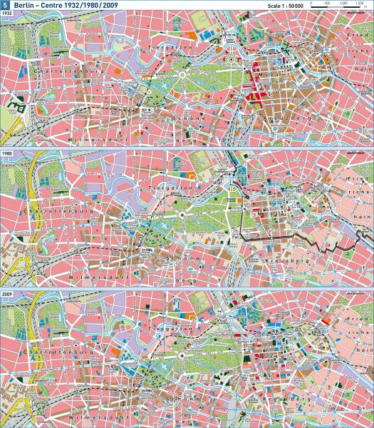
Information
The time-series map shows the changes in the inner city districts of Berlin, taking the example of the two traditional city centres — the old city centre of East Berlin and City West in Charlottenburg — and the new centre at Potsdamer Platz that has emerged since 1990. These make apparent the impact of socio-political systems on urban development, as well as the reshaping of the transport system and the traces of economic and cultural change.Politics and Society
In 1871 Berlin was the capital of the German Empire, and later it was the capital of the Weimar Republic. The government buildings were concentrated on the western edge of the old city centre. Some of these buildings, for example the Reich Chancellery, were destroyed in the Second World War, while others were kept in use by the GDR government (such as the "House of Ministries") or were reserved for representative purposes after the division of Germany (the Reichstag, the seat of Parliament). The political centre of East Berlin moved to the heart of the old city centre (Spree Island).
The political upheaval in the GDR led firstly to the opening of the Berlin Wall on 9 November 1989, and shortly afterwards, on 3 October 1990, to the reunification of Germany and the two halves of the city. On 20 June 1991 the German Bundestag decided, after a long controversy, to transfer its seat to Berlin and thus set the course for the city's future development. In the course of the following ten years the full ability of Berlin to function as
