
The formation of a Hurricane
The Americas - Climate
978-3-14-100790-9 | Page 127 | Ill. 5
Information
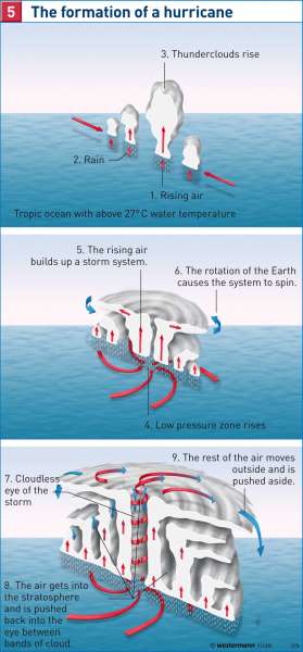
Every year there are between 30 to 100 tropical cyclones worldwide. These are known as hurricanes in the Caribbean, typhoons in the Indonesian area and in the regions of Australia, known as "Willy Willies" (dust devils). Hurricanes mainly occur from June to November.Tropical cyclones can only develop over seas with water temperatures of at least 26-28 °C. The store of these water bodies and subsequent unstable, humid air masses rise with the influence of the Intertropical Convergence Zone (ITC) and form huge, towering clouds, so-called "cloud clusters". The rise of warm air creates low pressure on the ground which attracts warm, moist air masses from all sides that permanently feed the vortex. Towering above the clouds, the air is thrown outward, where it sinks back to the ground. This creates a constant air circulation. The condensation in the rising air parcels and the released energy gives the air an extra boost and creates the power source of the characteristic turbulence. It is not until the onset of rotational motion of air masses that a tropical cyclone can be created. The Coriolis force keeps this circulation moving. Since this deflecting force is large enough to initiate a vortex formation, through the Earth's rotation, approximately as far as the sixth to eighth poleward latitudes, it straddles the cyclone free zone of the equator.
Wind circulation and migration
Hurricanes can have a diameter of several 100 kilometres. The winds circulate clockwise around the centre of the hurricane opposition and carry humid, tropical air masses northwards on its eastern side. On its western side, cold air is transported towards the south.
The centre of the hurricane increases toward the pressure gradient. Very high wind speeds occur partially of more than 300 kilometres per hour. However, there is almost no wind in the "eye of the storm", a 10—30 km wide zone in the core of the hurricane. This area is largely cloudless because of the descending air masses. Rings around the "eye" are air masses uplifted high into the air. These form powerful towering clouds (cumulonimbus), which descend in the form of torrential rain and thunderstorms.
Caribbean hurricanes usually travel on the western flank of the North Atlantic, sub-tropical highs clockwise to the north. Due to falling water temperatures, the cyclones then weaken, particularly when reaching the mainland. Coastal hurricanes often cause terrible damage. The extremely high winds and torrential rains can be accompanied by huge tidal waves. The storm churns up the sea water into high waves that can penetrate far inland and cause massive destruction and flooding.
A. Siegmund, D. Volz, P. Frankenberg; Ü: C. Fleming
