
Hawaii
Australia/Oceania - Physical
978-3-14-100790-9 | Page 117 | Ill. 2
Information
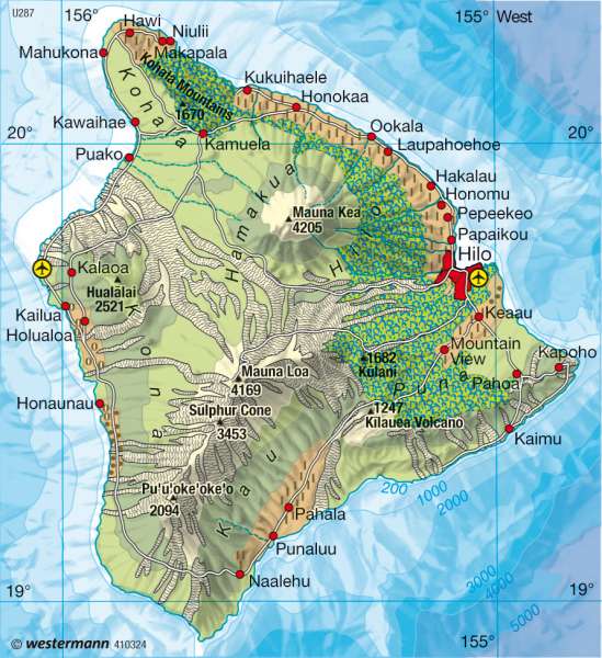
The Hawaiian Islands are the only major island group in the central North Pacific. Its land area is just under 17,000 km². Apart from the four major Hawaiian islands, Maui, Oahu (with the capital, Honolulu) and Kauai, there are over 120 other islands on the archipelago, many of which are usually small and uninhabited. More than 1 million residents live on the main islands and Hawaii is a state of the United States.Volcanism
The Hawaiian Islands owe their existence to the crossing of two tectonic lines (with a north-westerly and north-easterly strike direction). The islands, which are built from huge volcanic cones, also play a role especially on the smaller islands, coral and lime reefs.
The volcanic tapered cones were formed by many thousands of lava flows discharges which were gradually constructed. Lava which flows from the smokestacks of the great volcanoes is thin. It constructs so-called shield volcanoes with a slope of up to 10 degrees. Sudden eruptions, with disastrous consequences (e.g. Vesuvius) don"t happen in Hawaii because of the quiet lava discharges.
The namesake of the archipelago, Hawaii, is the largest of the islands with a land area of 10,400 km². The most famous volcanoes in Hawaii are the Mauna Kea (extinct), the Mauna Loa (active) and Kilauea (active) on the west flank of Mauna Loa. The highest astronomical observatory in the world is at Kilaulea, a volcanic observatory on the summit of Mauna Kea.
Climate
Temperatures are warm and balanced year round because of its location in the tropics. The map, in addition to altitude, shows a contrast between the northeast and the exposed south west coasts. The most populated areas in the northeast, intensively used zones are more or less broad strips of rainforest than original vegetation. These forests are missing in the east and south of the island. The cause of the contrast is the spatial distribution of rainfall on the windward side and the less-favoured leeward side. In the summer predominantly northwest-southeast oriented equatorial currents occur. They blow with extraordinary durability. Due to the orographic process, precipitation on the island"s high mountains, is among the most intense on the earth ( Mt Waiale on Kauai, 1,548 metres high has 12,547 mm mean annual rainfall). The highest rainfall does not fall on or near the mountain peaks, but at medium altitudes (1,500 metres). On the map showing the contrast between the windward and leeward sides, it is also clear that there are no rivers in the east and south. It also shows the few rivers in the northeast are temporary water flows while the numerous rivers on the windward side are in constant flow. Equally striking, is the difference between northern and southern slopes of the high mountain ridges, where the Kilauea lies.
Economy and settlement
The Hawaiian Islands are a major tourist area and a major U.S. military base. In addition, there is the cultivation and processing of sugar cane, coffee, nuts and fruit (pineapple, bananas), vegetables and flowers. The cultivation of crops in the drier leeward side partially requires additional irrigation. The settlements are usually on the favoured sides of the island. A circular road and two cross-links open up the island. Ferry and air services connect the islands and the United States. Hawaii is also a frequent stop over for trans-Pacific flights to and from the United States.
M. Felsch; Ü: Colette Fleming
