
The World - Thermal climate zones
Climate zones
978-3-14-100890-6 | Page 16 | Ill. 1
Overview
Climate classifications are an important basis of geographical spatial analyses. Presented in the form of a map, they systematically show the spatial distribution of climatic conditions on earth. They provide a good overview of the most important climatic characteristics of a region. In climate maps, however, only a few climate parameters can be taken into account. Only in this way, however, is it possible to abstract, typify and classify certain climates despite the continuous change in climatic conditions on earth.
The starting points for the classification using the Siegmund/Frankenberg approach are the three climate elements of temperature, precipitation, and potential evapotranspiration. By consistently referring to these, each climate can be assigned without doubt to a certain climate zone and a specific climate type.
While maps 16.1-2 and 17.3 present elements of the climate classification or summarise statements from it in simple way, map 16.4 shows their cartographic realisation in combination with the three climate keys, in addition to representations of coastal fog and ocean currents.
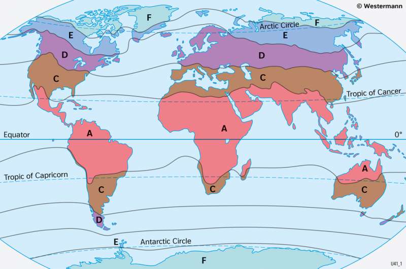
First climate key: Thermal climate zones
Heat and water balance are the essential variables of the natural and cultural conditions of an area. They are therefore central to the Siegmund / Frankenberg classification approach. Thus, the division of the Earth into five thermally defined climate zones (see 16.1) forms the basis of the climate classification (see 16.4). The annual average temperature of a climate station serves as a simple yet meaningful classification criterion. The thermal climate zones are abbreviated by the capital letters A, C, D, E and F.
A zonal arrangement of the thermal climate zones A, C, D, E and F is initially apparent across the Earth. This is almost ideal for the polar and Subpolar Zones as well as the Mid-Latitudes of the Southern Hemisphere. There, only the southern tip of South America, Tasmania and New Zealand cause minor bulges.
Particularly for the large continents, however, the climate zones often do not run parallel to the latitude circles. In the southern part of Africa, for example, there is a southward bulge in the tropics caused by the comparatively stronger heating of the land masses compared to the oceans. At the same time, the subTropical Zone on the west coast of southern Africa runs relatively far north in a narrow strip parallel to the coast. This is caused by the cold Benguela Current, which leads to the formation of fog and reduced solar radiation. Correspondingly, the California Current on the Pacific coast of Central America, for example, causes the subTropical Zone to extend southwards.
In western and northern Europe, as well as on the west coast of North America, warm ocean currents cause the Mid-Latitudes to bulge far to the north, even into areas north of the Arctic Circle. Both North America and Eurasia therefore show a contrast between the western and eastern sides of the continents.
