
The World’s extreme climates
Climate zones
978-3-14-100890-6 | Page 16 | Ill. 2
Overview
Climate classifications are an important basis of geographical spatial analyses. Presented in the form of a map, they systematically show the spatial distribution of climatic conditions on earth. They provide a good overview of the most important climatic characteristics of a region. In climate maps, however, only a few climate parameters can be taken into account. Only in this way, however, is it possible to abstract, typify and classify certain climates despite the continuous change in climatic conditions on earth.
The starting points for the classification using the Siegmund/Frankenberg approach are the three climate elements of temperature, precipitation, and potential evapotranspiration. By consistently referring to these, each climate can be assigned without doubt to a certain climate zone and a specific climate type.
While maps 16.1-2 and 17.3 present elements of the climate classification or summarise statements from it in simple way, map 16.4 shows their cartographic realisation in combination with the three climate keys, in addition to representations of coastal fog and ocean currents.
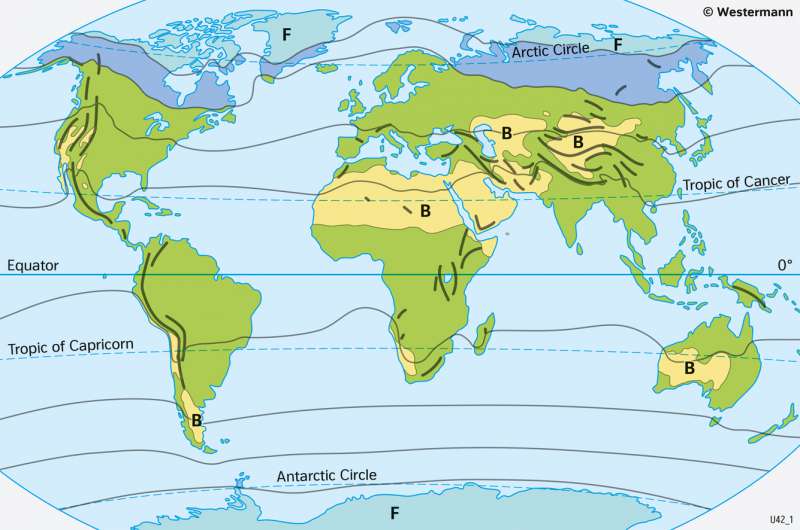
Extreme climates
In addition to the five thermal climate zones of the First Climate Key, the dry climates are additionally separated from zones A, C and D and combined into a separate climate zone named B. The 250-millimetre isohyete of the annual precipitation is used to distinguish the dry climates from the other climate zones. However, this only applies to the tropics, subtropics, and Mid-Latitudes in order to exclude polar and subpolar cold deserts, where very low precipitation can also occur, but where natural boundaries are set primarily by low temperatures.
In the climate classification 16.4 following the Siegmund/Frankenberg approach, the zoning described above is further differentiated by the altitudinal climates (see below) and completed by brief statements on agricultural usability.
With the help of the annual average temperatures (< -10 °C) or the dry climates (annual total precipitation N < 250 mm), those regions of the Earth in which a particularly low temperature or permanent or periodic water shortage are dominant can be located easily. From this, it can be deduced that such a region cannot be used intensively for agriculture.
