
South Asia — Monsoon
Asia - Agriculture and climate
978-3-14-100790-9 | Page 95 | Ill. 5
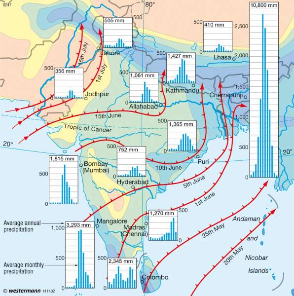
Information
The difference in the warming of sea and land brings about a monsoon tropical airflow with its dimension and seasonal change of direction of decisive importance for the vegetation and human life in South Asia.The winter monsoon
The winter monsoons in South Asia are driven by a ground-level air current that blows from the north of the continent to the Indian Ocean. It is dominated by shifted entropic south westerly wind currents that flow together to be divided by the Tibetan Plateau into a northern and a southern branch, and again in the leeside of the highlands (Tibetan Convergence Zone).
The cold, snowy winter in the Tibetan plateau is formed over the winter from a shallow, thermal high pressure area. This refrigeration causes a large temperature contrast to the south, which drives and anchors the southern branch of the entropic west wind jets. Sinking motions cause an outflow of ground-level jet stream dry winds to the south. Therefore droughts occur during winter in large parts of India. Only in Northern India and Pakistan do scattered depressions cause entropic winter rains in the western flow. Whereas in the leeside of the Tibetan plateau, the two branches of the westerly jets flow together. It is thse disturbances east of the continent which bring the wintry rainfall to northern China. Extremely cold air from the north flows into these depressions and can form snow storms known as "Burans".
From March, elements of atmospheric circulation shift abruptly, with changes in the sun to the north. Only the southern branch of the west wind jets remains cold, due to the rugged Tibetan plateau south of the Himalayas. The weather becomes hot and dry in northern India due to the high irradiance. This is known as the "pre-monsoon phase". Interaction of cold air with humid and unstable air masses of tropical disturbances results in low pressure atmosphere "squall lines" on the ground in the Ganges delta. Interaction of upper level divergence, in a trough of the southern branch of the west wind jets and ground level contact with warm air over the Gulf of Bengal in advance of the equatorial trough to the north, causes high rainfall in the north.
The summer monsoon
Summer marks the beginning of the monsoon season in Bengal, Bangladesh, Assam and Buam. The equatorial trough is over India, as it represents the Intertropical Convergence Zone (ITC). In China, the winter weather largely continues at this time.
In early summer, the westerly wind flow eventually breaks south of the Tibetan plateau, together with further weakening of the temperature contrasts between Tibet and the Indian Ocean. The entire entropic west wind drift now flows north of the Tibetan highlands. The tropical "easterly jet" forms over India through the heating of the eastern flow in high altitude plains. With the development of this jet, the way is cleared for approximately 3,000 metres of powerful, southwest flow of actual monsoon that moves over India and with a more southern flow to China. This summer southwest monsoon flows to the equatorial trough of the Intertropical Convergence Zone, whose low pressure trough moves from southwest India to the north of the subcontinent. As a result, the first monsoon rains begin in the southwest of India in late May and mid July, with the monsoon front reaching its northern most position. The "tropical easterly jet" ensures a shifting of the southwest monsoon flow in the shallow areas of low pressure troughs and causes convective clouds. It is only in northwest India that cold continental air flows through the monsoon current and prevents convection, where it remains mainly dry.
Through the stimulated "tropical easterly jet", embedded in the south-westerly monsoon, currents are particularly strong at between 1,000 to 1,500 metres, where the swift wind band of the "Somali-jet" develops. The latter extends over Madagascar to East Africa and then to India. If it crosses the Western Ghats, it forms convection clouds and leads to increased congestion of the coastal, mountain monsoon rainfall.
Monsoon- depression and cyclone
However, the monsoon rainfall over India derives not only from the south-west monsoon current, but also from so-called monsoon depressions that develop over the warm Gulf of Bengal. In the summer high rain troughs, above the west wind drift "tropical easterly jet," cause on average, twice monthly vortices to form at low pressure.
This monsoon depression is involved in a horizontal extent of over 1,000 miles in the tropical eastern flow. Thereby, this attracts the opposite to the direction of the shallow south-west monsoon from the Bay of Bengal to the west and northwest. Over land, they directly lead to extremely high rainfall in East India and Bangladesh. The highest rainfall amounts reached are in the congestion of the Himalayas. Between the storm tracks of monsoon depressions and shallow southwest, monsoon flows from the Indian Ocean and the hinterland in south-western India (Deccan Plateau). The leeside of the coastal ranges of the Ghats remains in low rainfall all year round.
In the northern migration of the rain front (equatorial trough) in the tropical eastern flow, the zone of maximum rainfall in India shifts from May to July to the north, with the retreat of the high sun towards the equator. Between July and November, the monsoon rainfall crosses the Indian subcontinent again with its front. Its repeated passage leads to two peaks of monsoon rains in South India, especially in Sri Lanka.
The Indian monsoon is often unreliable. Often enough, the northern shift of the monsoon front delays in the summer or the monsoon rains dissolve. Causes of such "breaks" in the monsoon are meridional air currents, which may occur through a temporary resolution of the entropic west wind jets. Consequently, with the Tibetan high altitudes, the tropical eastern flows are also weakened, which can lead to a collapse of the monsoon front.
In autumn, another special phenomenon occurs in Southern India. With a short-term confluence of the eastern equatorial flow positioning itself again with the equatorial westerly winds, cyclones form, leading to a maximum rainfall in October/November.
P. Frankenberg, A. Siegmund, D. Volz; Ü: C. Fleming
