
Eurasia — Physical map
Eurasia - Physical
978-3-14-100790-9 | Page 90 | Ill. 1
Information
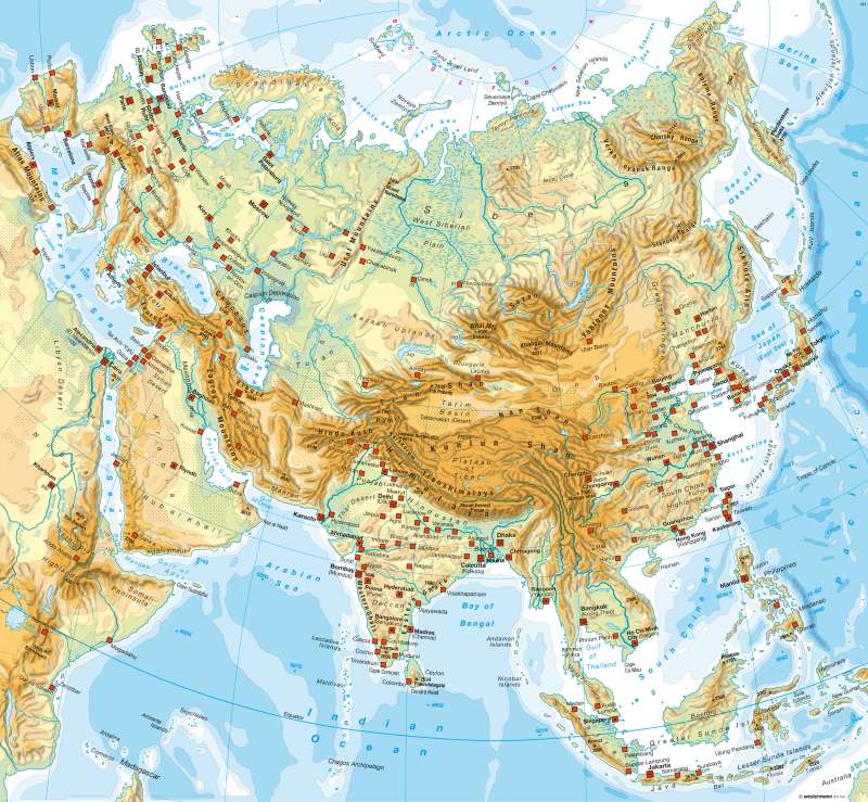
Asia includes all geographical regions from permanent ice areas and tundra in the north, to the tropical rain forests of Southeast Asia at the equator. The distinctive high mountain ranges of central Asia and the exposure to the coasts cause an intense overprinting of the zonal structure and contribute to the occurance of very contrasting landscapes. A particularly striking example is the extensive dry areas and highlands in the interior of the continent.West and South Asia
A broad belt of high, geologically young mountain ranges runs through the map image. West Asia separates the Caucasus and Taurus from the Eastern European plains of Mesopotamia and arid Arabian Peninsula. In the highlands of Iran, there is a widening of the mountain belt whose desert forms north of Alborz and Kopetdag, and are the vast plains of central Asia. The Himalayas mark the boundary between the highlands of Tibet and the Indian subcontinent, which are further divided into the current levels of the highlands of the Deccan and the mountain ranges of the Ghats. The Kunlun Shan leads north through the highlands of Tibet to the landscapes of the geologically older mountains, highlands and basins of central Asia.
North Asia
North Asia, ranges from the shores of the Arctic Ocean to the Kazakh threshold and the edge of the highlands and basins in the south (Altai, Sayan, Jablonowyi), from the Urals in the west to the Pacific Ocean in the east. It is divided into three parts of its surface shape and formation: In addition to originating from the Paleozoic West Siberian Plain between the Urals and the Yenisey, there is the central Siberian geologically ancient hills between the Yenisei and Lena (Central Mountains, Angara Shield), and the young mountain chain east of the Lena, including Kamchatka and Sikhote-Alin, with some active tectonics. The islands in the Arctic Ocean as well as the bulked coastal plains, rarely reach larger expansions to form separate spatial units. Tundra and boreal forests in western Siberia and extensive swamps, characterise the large scale picture of the landscape which is very thinly populated and barely developed, with the exception of the Southeast.
East Asia
East Asia is in contrast between the mountains, highlands (Tibet) and desert-like basins (Gobi Desert, Tarim, Qaidam, Dzungaria) and Central Asia on one hand is determined by rich fertile and densely populated plains. Also the river the deltas of great rivers, mainly of the Mekong, are amongst the largest plains as compared to favourable areas. Within the mountain ranges, the densely populated Red Basin occupies a special position.
The coast towards the mountains of East Asia are indeed lower, but still at considerable heights (Annam, Wuyi Shan). The Korean Peninsula and the main island of Taiwan have pronounced mountain characteristics.
Japan's mountainous interior is also largely covered by forests and only the valley bottoms of some river valleys are used for agriculture. There are few coastal plains (i.e - for example, Tokyo) - and a relatively narrow coastal strip, which adjoins the settlement areas and also competes strongly with use for agriculture. A particular problem in Japan is the risk from earthquakes. The active tectonics are also evident in the numerous volcanoes.
Southeast Asia
Southeast Asia consists of numerous, mainly mountainous islands of the Malay Peninsula and of Thailand, Laos, Cambodia and Vietnam collected in the northern tip of the mainland. Mountain barriers geographically arise in this area and the climatic boundary between the tropics and subtropics shows a clear differentiation between East, Central and South Asia.
A high intensity of tectonic activity is typical - whether through volcanism, earthquakes and crust movements within the geologically young island groups lying along plate boundaries. In particular, this concerns those plate boundaries that border the deep-sea trenches, as in the case of the Philippines. However, Borneo, forms a relatively stable core. On large islands, such as Sumatra, a significant difference between the high reaching mountain ranges and vast, often marshy plains can be seen. Through a comparison between the inaccessible coastline of Borneo and Java's fertile volcanic soil, it is evident how strongly the natural conditions of an area influence the population density.
M. Felsch; Ü: C. Fleming
