
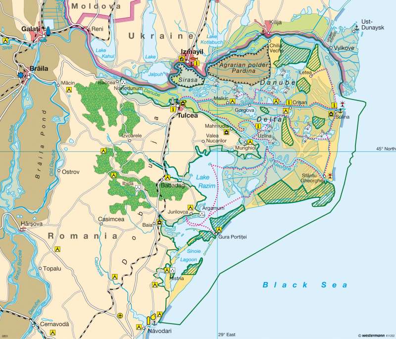
Danube Delta (Romania) — Environmentally-sensitive tourism
Southern Europe - Tourist destinations
978-3-14-100790-9 | Page 79 | Ill. 4
Information
With a length of 2,850 kilometres, the Danube is the second-longest river in Europe (after the Volga with 3,688 kilometres). It flows into the Black Sea on the borders of Romania and the Ukraine in a fan-shaped delta with a surface area of some 4,300 km². The delta forms the beginning of an international waterway that links the Ukraine, Romania, Bulgaria, Serbia, Croatia, Hungary, Slovakia, Austria and Germany to one another.Biosphere Reserve
The Danube is the most important receiving river in south-eastern Europe and the catchment artery for the great rivers of the Eastern Alps (Inn, Drava), the Carpathians (Tisza) and the eastern Dinaric Alps (Sava). At the start of the delta west of Tulcea, at Ceatal, the average flow amounts to 7,320 m³/sec. However there are substantial differences between low water (2,000 m³/sec) and high water (24,000 m³/sec). For comparison: at Passau an average flow of 1,415 m³/sec has been measured. Downstream from Ceatal the river divides into the three great arms of Chilia (c. 60 percent), Sfântu Gheorghe (St. George, c. 30 percent) and Sulina (c. 10 percent). Today the river, which is navigable from its mouth as far as Regensburg, no longer plays any significant role in the transport of passengers or goods, and in this respect the delta region is practically unimportant.
This extremely thinly-populated region with its approximately 3.5 inhabitants per square kilometre, which is remote from both the Romanian and the Ukrainian perspectives, counts as the largest wetland region in Europe and as an important refuge for countless plants and animals. The broad river mouth region is dominated by large quantities of reeds. Floating reed islands, driven by the currents, move through the amphibian zone, which is subjected to constant change. The waters are enclosed by natural levees, which however are flooded at every (summer) high water. In winter, when continental north-easterly winds bring the icy cold, the watercourses often freeze over for weeks at a time. In February, for example, the temperature can fall to minus 30 °C. Despite this hard winter, the waters, marshy woodlands, dunes and meadows of the delta are habitats for many bird species — including duck, pelican, heron and white-tailed sea eagle — numerous fish, amphibians and insects, as well as wild cats and martens. In 1991 this unique ecosystem was declared a UNESCO World Heritage Site.
Coastal morphology
Parallel to the coastline, especially in the vicinity of the St. George arm, is a series of numerous dune belts arranged in stages, indicating former coastlines. The coastal morphology processes are comparable to those in other deltas. On the heavily-regimenting Chilia arm, especially east of Vylkove, the coastline is advancing ever further; currently by four to five metres per year. In the 15th century, the port of Chilia Veche (Old Chilia) was still only five kilometres from the sea, but today it is around 30 kilometres. The southerly-flowing St. George arm is also strongly advancing into the sea. Its suspended sediments — amounting to some 80 million tons per year — are transported to the south-west by the ocean currents. The long sand bars which came into being due to the deposit of sediment have formed today's Razim lagoon and its neighbouring Sinoie lagoon from former bays of the sea.
The Sulina arm, at 72 kilometres the shortest of the three arms of the river, is currently no longer growing. To secure the passage of ships, concrete walls were built far out into the sea, with the result that the suspended sediments are carried out to sea and are no longer available for new coastal formation. The numerous stagnant waters in the Delta are cut off from the supply of settling sediments, which explains why they are only silting up gradually.
Features specific to the western Black Sea coast are the Yalpug and Kotlabuch lakes on the Ukrainian side of the Delta. These long, deep lakes are so-called limans, "drowned" Pleistocene river mouths (Ria), that were separated from the open sea in the Holocene era by sediment deposits from the Danube.
J.-B. Haversath; Ü: J. Attfield
