
Southern Europe / Turkey — Physical map
Southern Europe / Turkey - Physical map
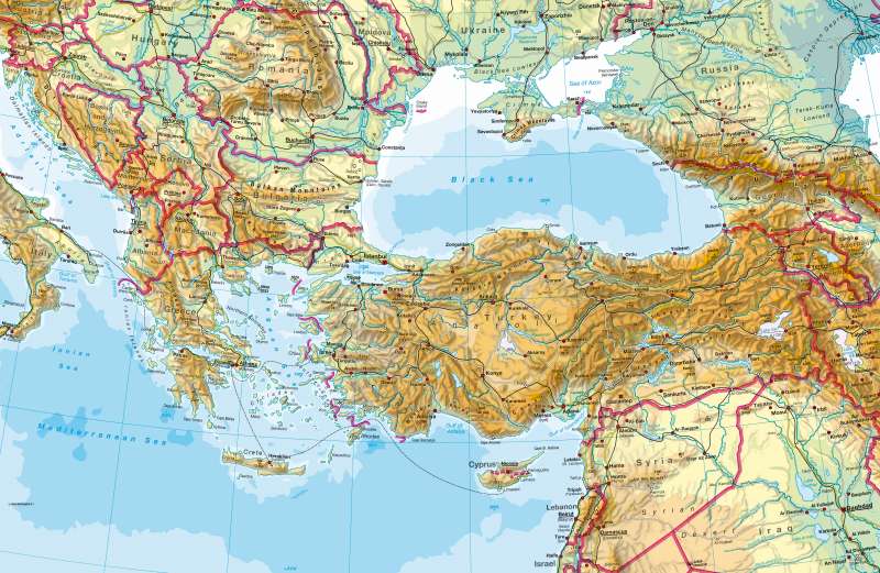
978-3-14-100790-9 | Page 76 | Ill. 1
Information
Southeast EuropeSouth Eastern Europe, the eastern Mediterranean and Turkey have almost fully retained their shape during the phase of young alpidischen orogenesis. The mountain ranges are at their highest in the Carpathians, Rhodope, Taurus and Caucasus. To the east, the great lakes such as Lake Van and Lake Urmia lie within the mountain ranges. The system of large reservoirs on the upper reaches of the Euphrates, suggests a central aspect of this region and a conflict point: the water supply.
Narrow coast seams lead from the mountains to the Mediterranean Sea and its marginal seas such as the Aegean and Adriatic Sea. Here, numerous groups of small islands can be found. Cyprus and Crete are the two largest islands of the eastern Mediterranean and both have mountain characteristics.
Exceptions within the mountain ranges are the broad span of landscapes, traversed by major rivers of the Pannonian Basin and the Turkish Anatolia, which are framed by the Pontic and Taurus Mountains. Along the coasts, plains appear in greater extents where large rivers have deposited their sediments (Danube, Seyhan / Ceyhan pipeline). In the north, the plains of the eastern lowlands rise in the southeast of the Arabian Peninsula.
The Mediterranean region has strong earthquakes because of the active tectonic fault lines.
Eastern Europe
Long-range depths, plaque and hill regions determine the surface shape of Eastern Europe. The mountains reach the higher altitude limits only in the south-east (Carpathians) and south (Yayla Mountains in the Crimea) in the East European Plain. In South Eastern Europe, the inland Caspian Sea, the Sea of Azov and the Black Sea are to the north of the Baltic Sea. At the centre, there is a wide transition zone (Poland). In the East, the Caspian Sea and Ural Mountains mark the boundary with Asia.
Within the eastern lowlands, two large north-south oriented plates don't fall anywhere beyond the 400 metres height. During cold periods of glacial deposits, ice reached its maximum extent as far as the Kiev-Lviv Kazan in north-eastern Europe. Outside the territory of the recent glaciation was a particularly broad loess belt, which is now the basis of extensive agricultural use. Traces of the last glaciation are also found by the many lakes in north-eastern Europe.
The large currents that flow through the lowlands, prominently display the encroachment of man into the water network. During the winter, the rivers are often frozen for several months.
M. Felsch; Ü: C. Fleming
