
The Ruhr circa 1840
Europe - Structural economic change
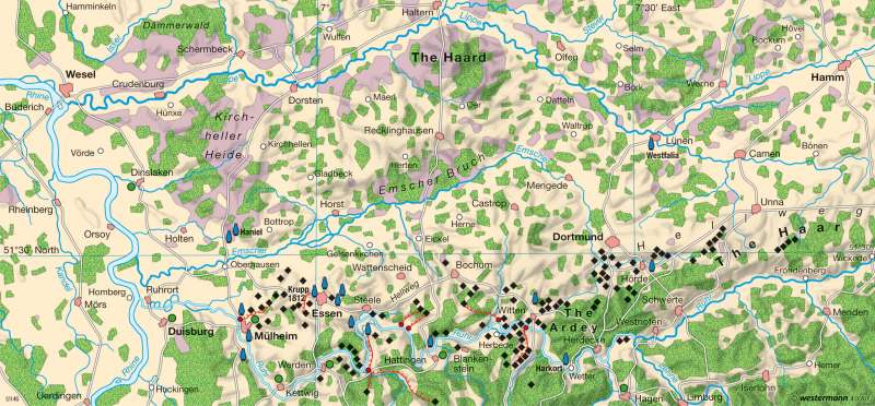
978-3-14-100790-9 | Page 53 | Ill. 3
Information
The map shows the physical division of the region that is generally referred to as the Ruhr Area or "Ruhrgebiet". Its division into the Ruhr, Hellweg, Emscher and Lippe zones in the East-West direction as well as the Rhine zone in the North-South direction is naturally predetermined. Clearly recognisable are the formerly heavily-wooded foothills of the lower Bergisch-Märkisch uplands and the loess terrace plates adjoining them to the north. On account of their fertile soils, these were almost completely deforested, brought under agriculture and relatively heavily settled at an early date (a series of settlements along the old trade route of the Hellweg, also called the "salt road"). Adjoining these are the swampy and therefore sparsely-settled Emscher lowland and the sandy region of the Kirchheller Heide.The Start of Industrialization
The map shows the concentration of more than 100 coal mines along the Ruhr as well as the developing metallurgical industry at the start of the period of high industrialization.
The launch-pads for industrial development were coal extraction and the smelting of ore to iron. Although coal extraction on the Ruhr was first documented as long ago as 1302, regular coal mining did not begin until 1766. It was favoured by the development of the Ruhr (locks) into a coal transport route in the years 1776 to 1780. The first coal railways ("Kohlebahnen") were horse-drawn lines terminating at "coal ports". The heyday of coal shipping on the Ruhr lasted for about 90 years. During this period the Rhine was, for a time, the most-navigated river in the world until the new railways won the competition for coal transport on account of their speed and greater spatial capacity. Ruhr shipping came to an end in 1870.
Decisive for the development of coal mining from the simple digging of coal from pits ("Pingenbau"; "Pütt" = a well-like shaft; from the Latin "puteus" for well), to drift mines tunnelled horizontally into a hillside, and then to the sinking of deep mines, was the solution of the drainage problem by means of steam engines and pumps. The first steam engine ("Feuermaschine") was brought into use at the "Vollmond" mine in Bochum in 1799. Along a line south of the cities of Essen—Dortmund the coal-bearing layers reach the surface, while to the north of this line they are covered by an ever thicker layer of marl. Between 1832 and 1834 Franz Haniel succeeded for the first time in sinking a shaft through the marl layers north-west of Essen.
The development of the iron and steel industry is closely associated with the names of Friedrich Krupp (1812: Essen), Franz Haniel (1830: first rolling mill in Sterkrade) and Fritz Harkort (1826: in Wetter the first "puddling furnace", from "to puddle" meaning to stir). A further landmark was the construction of the first coke-fuelled blast furnace in Mülheim in 1849. At that time the Ruhr Area only accounted for five percent of Germany"s raw iron production. Now, however, its location "on the coal" became decisive, because about two tons of coke were required for the smelting of one ton of ore (today only 0.5 tons are required). Thus the development of smelting technology, the extraction of bituminous coking coal in deep mines that had now been made possible, and the transport services of the newly-built railway (1847 Cologne—Minden), formed the preconditions for the Ruhr Area to become the greatest industrial region of the continent.
E. Michel; Ü: J. Attfield
