
Geographic models of the European economy
Europe - Structural economic change
978-3-14-100790-9 | Page 52 | Ill. 1
Information
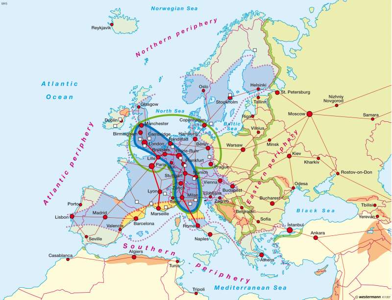
There are numerous cartographic representations of the spatial structure of the economy of Western Europe. These are also called geodesign or spatial models. They comprise abstract statements, both about actual real distributions and about politically desired, anticipated or assumed spatial changes. They are therefore ambiguous and subject to frequent extension and variation.The "Blue Banana"
The graphic is based on the visually-striking thesis sketched out by the French geographer Brunet in 1989. It was his belief that Paris would be likely to decline in importance, as a consequence of advancing Europeanization and the remote location of the French capital outside the backbone of Europe, if the then French policy of decentralization at the expense of the capital city were to be continued. Therefore this graphic only covered what was then Western Europe.
After the fall of communism in Europe, the graphic — which had captured much attention under the memorable name "Blue Banana", coined by a French journalist as an analogy to the economic term "Blue Chip" — was expanded with additional content and extended graphically to Eastern Europe. Particularly noteworthy here are the arrows for the hoped-for east-west connections as well as for those to Turkey and to the opposite coast of the Mediterranean. Here, the axes indicate the dominant directions, but not the existence of any bundled infrastructures or interconnected economic areas. Furthermore, the currently politically insecure (Kosovo) and economically weak Balkans (Bulgaria, Romania, etc.) are highlighted graphically as a wedge.
The "Blue Banana" stretches from Birmingham, via London, Brussels, the Randstad, the Ruhr Area, the Rhine axis, Basel and Zurich, as far as Milan, Turin and Florence, and is then continued in different ways in different versions of the graphic — in the present map it reaches to Rome.
Further Core Regions
In the last two decades the core region has been supplemented with further graphical elements. The first one to mention is the "Yellow Banana" which stretches from Paris through Brussels/Amsterdam to Hamburg and, generously interpreted, reaches as far as Berlin. Alongside this, within the "Blue Banana" there is a reference to a possible shift of focus from the Bonn/Düsseldorf area to the Rhine-Main and Rhine-Neckar regions, which can also be traced back to the decision of the European Central Bank to locate in Frankfurt am Main. A dotted line symbolizes the "economic heart" of Europe. In the literature one also finds further images and metaphors such as that of the "decision-making triangle", which refers to Paris, London and Brussels.
The term "belt of high-tech regions" — situated outside of the core region — draws attention to the importance of cities like Toulouse, Glasgow or Copenhagen. The term "sunbelt" was coined as an analogy to the success story of Silicon Valley in California, and refers to regions with "soft" locational factors such as coasts, sun, mountains or snow. Examples of this are the Sophia Antipolis Technology Park near Nice, or Barcelona (1992 Olympic Games).
Peripheries and Problem Regions
The peripheries stand at the opposite pole to the core regions. The southern periphery includes the — by EU standards — economically poorer regions stretching from Portugal, through Sardinia and southern Italy (Mezzogiorno), to Greece and the European part of Turkey; its borders could also take in Albania and Montenegro. The "axis of problem regions", or the "diagonal of difficulties", has a more symbolic than real meaning. It could also include particularly structurally weak regions such as the Massif Central or Mecklenburg-Western Pomerania. To some extent the "axis of problem regions" cuts through the "Blue Banana" and thus draws attention to the "fragmentation" of the European space, i.e. the fact that highly contrasting locational categories, such as classic older industrial areas and new investment locations, or particularly poor or rich regions, are often situated adjacent to one another. There is also a similar fragmentation within the spatially-interconnected periphery; examples of this are the intensive agricultural cultivation near Almería on the southern coast of Spain, or the expanding modern city of Dublin on the Atlantic periphery.
In terms of regional planning policy, the antithesis to the model of "bananas" and core regions would be a "bunch of grapes model" with a large number of centres of equal weight. This model would represent the symbol of a development towards a more balanced structure, in contrast to the present spatial structure with its rich core regions and economically poorer peripheries.
F. Werner; Ü: J. Attfield
