
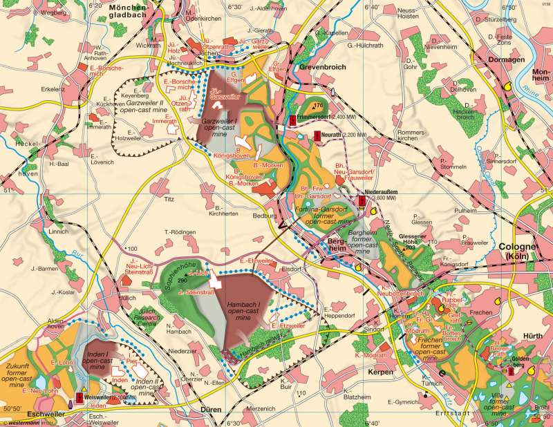
Rhenish lignite mining — Landscape change
Europe - Energy
978-3-14-100790-9 | Page 49 | Ill. 4
Information
The impact of expanded lignite mining operations on the landscape in the Lower Rhine Basin exhibits a regionally differentiated structure. Three factors have contributed to these changes: preparations for mining (Garzweiler II, Hambach, Inden II), actual mining operations (Garzweiler I, Hambach, Inden I) and recultivation measures (former opencast mines at Fortuna-Garsdorf, Frechen, Ville; Garzweiler I [eastern section], Sophienhöhe).Landscape recultivation
Outstanding examples of the recultivation measures that have given a new face to a landscape that had been ravaged by opencast mining are those undertaken in the southern district, where mining operations were discontinued following the depletion of coal deposits at the Ville mine south of Goldenberg in May 1988. All of the standard approaches to recultivation are found here in close proximity to one another. The basis for forest recultivation efforts since 1960 is forest gravel, a mixture of Pleistocene sand, gravel and loess which forms a layer measuring four metres in thickness. Valuable native trees such as beech, oak and evergreens as well as smaller stands of deep-rooted black locust, alder and poplar were planted on this foundation. Most of the remaining pits were filled to form lakes. Sixteen of these lakes are located in the area south of the Autobahn between Cologne and Düren alone. These forested areas and lakes are now part of the Kottenforst-Ville nature park, a local recreation area serving the greater Cologne-Bonn metropolitan area. Other pits were converted to dumping grounds and landfills for household waste, power plant ash and hazardous waste (e.g. Ville).
The first step in landscape recultivation was to spread a two-metre-thick layer of loess using a dry application process. The fields were then cultivated during a seven-year preparation phase for the purpose of activating biological processes in the soil before being turned over to local farmers. Soil quality is warranted for a period of 25 years. In some places, such as the Berrenrath Hamlet, fields are farmed from new settlements consisting of between six and ten farms, as this form of settlement is more advantageous than single-farm operations in the midst of the cultivated areas.
Industrial use
Former lignite mining areas also serve as industrial sites. These include the five power plants located in the region, among them the Niederaussem plant, which is now regarded as the most modern brown-coal power plant in the world following the completion of the last block in 2003. Power plants, heat and power stations and district heating plants consume by far the greatest share of lignite produced in Germany (91 percent). The remainder is used in refineries, which convert the coal to lignite dust for large combustion plants or to briquettes, fluidized-bed coal or filtration coke. Other energy-intensive industries, including the aluminium smelting and chemicals industries have also settled in or near former lignite mining areas.
Land utilization conflicts
Land utilization conflicts often emerge within the context of lignite mining operations, as was the case in the Rhenish mining region. Whereas brown-coal mining once competed primarily with forestry, its most important competitor today is agriculture. One argument in favour of lignite production is the fact that it accounts for 24 percent of the German electrical power mix, and that 176 million tonnes of lignite were mined in Germany in 2006 — of which 55 percent came from the Rhenish lignite mining region. Justified claims are expressed on the other hand by farmers, who run market-oriented, capital-intensive agricultural operations on an above-average scale on largely nutrient-rich loess plates measuring up to seven metres in thickness on lands around the Jülich Boerde, including the northern section of the Villehorst. Producers of food and semi-luxury food products, such as sugar and canned-goods, have also formed alliances with these farmers.
The present land utilization conflict is exacerbated by a number of circumstances, including the discrepancy between the demand for arable land and the availability of recultivated land and the exploitation of ecologically valuable areas such as the Hambach Forest for mining purposes. Conflicts between the brown-coal industry and other potential users are also fuelled by the fact that, as part of the fringe zone of the urban agglomeration known as the "Southern Rhine Track" is covered by a dense web of roads and highways and also has an above-average population density. For these reasons, it is subject to increasing pressure to promote the development of new housing, industrial and commercial areas (suburbanization).
In addition to the negative impact of opencast mining on groundwater levels, emissions from fossil-fuel power plants and the local basic materials industry also contribute to environmental pollution. Emissions of airborne ash, SO? and NOx have been reduced to below statutory limits by retrofitting power plants with flue-gas desulfurization systems. CO? emissions by brown-coal power plants continue to pose an environmental problem, however Efforts to reduce emissions by increasing net efficiency at these plants are currently in progress.
H.-J. Kolb; Ü: J. Southard
