
Vienna (Austria) — Imperial residence city circa 1850
Europe - The modern age
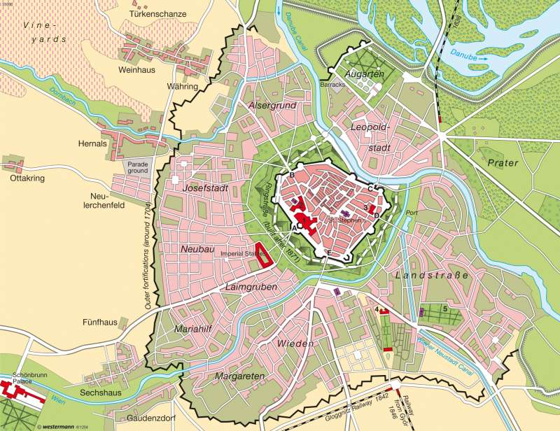
978-3-14-100790-9 | Page 35 | Ill. 3
Information
The map shows the city of Vienna at a significant historical turning point in the mid-19th century. The fortifications, which were razed only a few years later, were still in place at this time, and the Danube has not been regulated. The presence of the northern line and two rail lines in the South bear witness to the arrival of the railroads and the Age of Industrialization.Pre-medieval history
The city traces its history to the period of occupation by the Romans, who established a military camp and the city of Vindobona during the 1st century BC. Its location north-west of St. Stephen's Cathedral is visible on the map. Settlement progressed continuously during the Middle Ages. Vienna was first mentioned in written records in 881 and was awarded the status of a civitas in 1137. The city charter was granted in 1221. The charter also conferred the staple right, thereby establishing Vienna as an important trading hub.
Vienna remained in the shadow of the imperial residence of Prague during the reign of the Habsburgs from the 13th century onward. Yet the university was founded in 1365 and work on the construction of St. Stephen's Cathedral began shortly thereafter. Vienna became a bishop's seat in the 14th century and the residence of the Emperor in 1556.
The most obvious evidence of medieval urban development shown on the map is the wall around the city centre, on which construction began in the 13th century. The first gates were built a century later, among them the Stuben Gate in 1314. The fortifications eventually fell short of modern standards, as became evident during the Turkish siege of Vienna in 1529.
Vienna in the early modern era
Vienna's city wall was redesigned and reinforced with the help of experts from Italy beginning in 1548. The 300-metre-wide sloping field of fire outside the wall, known as the glacis, is recognizable on the map. Modernized in 1672, the fortifications were forced to withstand another siege by Turkish forces in 1683.
Population pressure increased, giving rise to new cities outside the walls, including Josefstadt in the West and Leopoldstadt on the opposite side of the Danube Canal. It was not until 1861 that work began on the demolition of the fortifications, thereby freeing space for the Ringstrasse, for which Vienna is famous today.
Expanded fortifications were erected in the form of the Line Wall around the western and southern suburbs in the early years of the 18th century. Today, the configuration of the structure, which was demolished after 1894, is marked today by the course of the urban beltway. The Goggnitzer and Raaber Railway Stations in the South were built between 1841 and 1846. They were replaced by the South Station, whose time came to an end when the building was demolished and converted into the new Central Station beginning in late 2009. The North Station at Praterstern shown on the map was not built until 1859.
Population growth and decline
Vienna's population was estimated at 113,000 circa 1700. According to the first census, 175,460 people lived within the city walls in 1754. The population increased rapidly thereafter, due in part to the annexation of nearby communities. Having approached the one-million mark in 1869 (900,998 inhabitants), the city's population swelled to 2.2 million by 1916, making Vienna the fourth-largest city in the world, after London, New York and Paris. Today, Vienna is home to 1.7 million people.
D. Falk; Ü: J. Southard
