
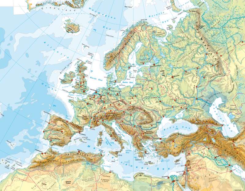
Europe - Physical map
Europe - Physical
978-3-14-100790-9 | Page 27 | Ill. 2
Information
Europe is a markedly segmented continent with large inland seas and long coastlines. Mountain ranges were formed through folding in three phases along geologically old shields which have been levelled to form expansive landscapes today. Depending upon their ages, these ranges have been eroded to a greater or lesser extent or reshaped into uplands by fracture tectonics in the course of geological history.Northern Europe
In Scandinavia, geological structures were aligned from north to south (early mainland and folded Caledonian mountain ranges), with climate zones distributed from north to south and differentiated by elevation. The Scandinavian Mountain ranges in the West and North-west contrast with the partial basins of the Balkan region and the predominantly flat landscapes in the East (southern Finland) and South (Jutland, southern Sweden). Some of the Scandinavian Mountains are of alpine stature and bear glaciers. An escarpment plain along a diagonal between the North-west and the South-east mediates between the Scandinavian Mountains and the Balkan Sea, and is most clearly evident in the parallel courses of rivers, especially in northern Sweden.
The Scandinavian region was covered by inland ice during the last glacial period. Accordingly, the surfaces forms along the coast, in valleys and on plains exhibit diverse traces of glacial and periglacial formation. The abundance of lakes is also attributable to these influences.
The unique character of the island of Iceland is due not only to its northern latitude (tundra vegetation). The Mid-Atlantic Ridge runs through the island and is responsible for active tectonic shifts and volcanic activities (geysers).
Western Europe
France encompasses expansive plains as well as hilly lowlands, basins and tablelands which are clearly bordered by the Atlantic, the Mediterranean Sea, the Pyrenees, the Alps and the Vosges. Only the Massif Central and the Cevennes in the South reach significant heights. Between the Vosges and the Central Massif, on the one hand, and the Jura and the Alps, on the other, lies a broad rift valley through which the Saone and Rhone Rivers flow. A broad transition zone to Central Europe lies in the region of the mouths of the Rhine, Maas and Schelde Rivers north of the Ardennes.
Great Britain is characterized by the contrast between the flat, undulating stepped landscape of south-eastern England and the Caledonian and Variscan Uplands of the Pennines, the Scottish Highlands and the Cambrian Mountains. Ireland exhibits similar contrasts.
Central Europe
See the annotations for the map no. 70_1
The Alpine Region
The Alps are part of the young alpidic fold-nappe belt. As high mountains, they form the climatic and historical boundary between Central and Southern Europe. Sharply delineated to the South toward the Po Valley, they are bordered by a relatively broad piedmont in the north, the boundary of which is marked roughly by the Danube and the Aare. A characteristic feature of the alpine region is a combination of ranges composed of both folded and thrust rock sheets. The former originated in the thresholds of the geosynclines sea. The western Alps are composed of several different ranges, including the Mont Blanc Range. They form two distinct zones in Switzerland, which are separated by the longitudinal valley of the Rhone (including the Aare and Gotthard Massifs). The eastern Alps comprise three mountain chains: the Northern Limestone Alps, the Central Alps (Tauern) and the Southern Limestone Alps. These chains are separated by longitudinal valleys (Inn, Salzach, Enns, Drau).
South-western Europe
The south-western Mediterranean region is defined by the coexistence of alpine landscapes and the Mediterranean Sea, including its islands.
The older ranges originated during the Variscan phase (Central Massif, the core of the Iberian Peninsula, Schotts Highlands). They are closely interlocked with the younger mountain ranges dating from the Alpidic phase (Cordilleras, Pyrenees, Alps, Apennines, Er-Rif, Atlas). The Mediterranean Sea lies between the European and North African mountain ranges, and its islands originated for the most part during Alpidic phase. A number of active volcanoes and frequent severe earthquakes are indicative of tectonic activity. Major plains (Po), valleys (Ebro) and expansive basins (Castillas) lie between or embedded in the mountains ranges. They are of particular significance to settlement and economic life, as is true of the more or less wide coastal fringes as well.
South-eastern Europe
South-eastern Europe, the eastern Mediterranean region and Turkey were shaped for the most part during the recent phase of Alpidic mountain formation. At their highest elevations, the mountain ranges exhibit the characteristics of high alps (incl. the Carpatians, Rhodopes, Taurus, Caucasus). Large lakes, such as Lake Van and Lake Urmia, are embedded in the mountain landscapes in the East. The presence of large man-made lakes along the upper reaches of the Euphrates is indicative of the most crucial issue and bone of contention in this region: the water supply.
Narrow coastal fringes mark the transition from mountain ranges to the Mediterranean and adjacent seas, such as the Aegean and the Adriatic. Numerous groups of small islands are situated here. Cyprus and Crete are the largest islands in the eastern Mediterranean, and both are mountainous.
Exceptions among the mountain landscapes include the expansive landscapes with major rivers of the Pannonic Basin and Anatolia in Turkey, which are bordered by the Pontic Mountains and the Taurus. Large plains were formed along the coasts, where major rivers deposited their sediments (Danube, Seyhand/Ceyhan). The plains of the East European lowlands are cut off in the North, those of the Arabian Peninsula in the South.
The Mediterranean region is severely threatened by earthquakes due to the presence of active tectonic fault lines.
Eastern Europe
Vast lowlands, tablelands and hilly landscapes shape the topography of Eastern Europe. Mountains which reach higher elevations border on the East European lowlands only in the South-east (Carpatians) and the South (Jaila Mountains on Crimea). Inland seas — the Caspian Sea, the Asovian Sea and the Black Sea — lie in the South-eastern Europe, the Baltic Sea in the North. A broad transition zone (Poland) separate Eastern from Central Europe. The Ural Mountains and the Caspian Sea mark the boundary to Asia in the East.
Two large plates aligned along a north-south axis are prominent features of the East European lowlands. Neither is higher than 400 meters at any point. North-eastern Europe was reshaped by glaciers during glacial periods. The ice reached its southernmost point along the line between Lemberg, Kiev and Kasan. An unusually wide loess belt formed outside the area covered by ice during the most recent glacial period provides the foundation for extensive agricultural operations today. Numerous lakes in north-eastern Europe also bear the traces of the last glacial period.
The major rivers that flow through lowland areas are as remarkable as the various human interventions in the network waterways. Rivers are often frozen over for several months during the winter.
M. Felsch; Ü: J. Southard
