
The world — Ecozones/vegetation
The world - Ecozones/vegetation
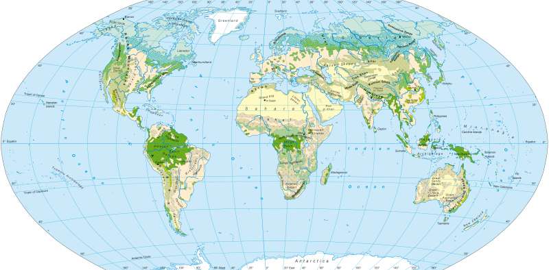
978-3-14-100790-9 | Page 178 | Ill. 1
Information
The map illustrates the distribution of vegetation zones on the earth today. The 13 different varieties of vegetation and land-use are distinguished here, and divided into three main categories: forest landscapes, open land and cultivated land.Distribution of Natural Vegetation and Impact of Humans
Despite the already wide ranging, marked impact of humans, it is still possible to see the zonal distribution of all of earth's vegetation belts on this map.
Monsoon and rain forest zones are located along the equator. Here the year-round rainfall is high (> 1500 mm per year) as is the temperature in the inner tropics (compare Atlas p.12), which results in evergreen rainforests with increased biodiversity. The duration of the dry season is limited to a maximum of two months; in wet savanna zones (three to five arid months) there are more or less clearly defined transitional zones (semi-evergreen rainforest with two to three arid months, 1100 to 1500 mm rainfall per annum). Monsoon forests are deciduous tropical humid forests with a higher number of arid months. The coasts in the tropics are frequently lined with mangrove forests.
The equatorial monsoon and rainforest zones in the tropics are connected to the more open land forms of the savanna, in the direction of the poles on both hemispheres. While the moist savannas (three to five arid months) still have quite lush vegetation with many trees (in part deciduous forests), the number decreases as the distance to the equator increases and the availability of moisture decreases. There is a transition into the arid savanna (five to seven arid months) and finally to the thorn savanna (seven to ten arid months, > 200 mm annual rainfall). Vegetation in the savanna has adapted to the periodical water shortages with appropriate forms (stem succulents, forest canopies). Parts of the savanna, particularly the arid savanna, are suitable for cultivated land use, and within the thorn savanna, irrigation is important, e.g. on the Niger and the Nile.
Distributed along the tropic lines are semi-deserts and deserts, above all in Africa, Western Asia, South Asia and Australia. Here the available rainfall is so low (< 200 mm annual rainfall on average), that only very sparse vegetation is able to propagate, if at all. There are significant differences between the various desert regions (e.g. compare Australia — Sahara)
The zone of the steppes and the high-mountain grasslands are connected to the desert belts in the direction of the poles. Steppes are mainly found in Central Asia, Eastern Europe, East Asia and east of the Andes in South America. They are often good locations for cultivated land because of the excellent soil, and therefore also extensively exploited for the production of crops (e.g. the Mediterranean in Eastern Europe, the Pampas in Argentina).
High-mountain grasslands are mainly spread in the interior of the Rocky Mountains (the Great Basin), in the high mountain valleys of the Andes, on the coasts of the southern Mediterranean, in the highlands of Iran and in the relatively high-rainfall areas of inner Asia (Hindu Kush, Tien Shan, Kunlun Shan, parts of Tibet). They are often preserved as semi-natural landscapes.
Alongside the steppes in the mid-latitudes, there are deciduous forests and mixed forests that are reliant on a certain amount of moisture. The distribution in the northern hemisphere illustrates a climatically-influenced contrast between the West and the East coasts, most noticable in Northern Eurasia. In the Altai regions, such forest zones do not exist at all. In arid-summer climates (the Mediterranean, California) there are very adaptable Sclerophyll forests, which dispose of a protective layer that prevents evaporation (above all through small, thick and in part wax-coated leaves). Widespread lush wetlands can be found along the humid coastal regions of North and South America
Further polewards, the northern coniferous forests (the Taiga in Siberia) are connected to the tundra. Here, the temperature conditions have a significant effect on plant growth.
The rainfall, in contrast to Central Europe, is mostly poor; the winters are very cold while the summers are warm. Because of the short summer growing season (three to five months), too short for the production of the leaves on deciduous trees, mainly coniferous tree varieties dominate in this region.
Large parts of the Arctic and the Antarctic comprise of the zone of the cold polar deserts, where plant growth is no longer possible. The temperature rarely goes above freezing point and precipitation is low. Due to the influence of maritime activity and continentality, large irregularities occur along the southern fringe of the polar deserts. The polar deserts reach far south (almost level with Oslo) down through Greenland's interior, while the coasts of Greenland and the Canadian archipelago, at over 80 ° north latitude, are covered by tundra.
M. Felsch, A. Siegmund; Ü: M. Dahl
